…where east meets west
- Home
- Brief History
- The Greenwich Meridian
- Greenwich
(1675–1958) - Herstmonceux
(1948–1990) - Cambridge
(1990–1998) - Outstations (1822–1971)…
- – Chingford (1822–1924)
- – Deal
(1864–1927) - – Abinger
(1923–1957) - – Bristol & Bradford on Avon
(1939–1948) - – Bath
(1939–1949) - – Hartland
(1955–1967) - – Cape of Good Hope
(1959–1971)
- Administration…
- – Funding
- – Governance
- – Inventories
- – Pay
- – Regulations
- – Royal Warrants
- Contemporary Accounts
- People
- Publications
- Science
- Technology
- Telescopes
- Chronometers
- Clocks & Time
- Board of Longitude
- Libraries & Archives
- Visit
- Search
The Observatory Garden (formerly the Lower Garden)
Once generally known as the Lower Garden, this part of the Observatory grounds was reintegrated into the Park with the bulk of it being formally opened to the public by the Queen during her visit to open Flamsteed House in 1960. At this point, it was renamed the Queen’s Garden. Although now generally referred to as the Observatory Garden, it has also been known as the Kitchen Garden, the Royal Observatory Garden, and the Astronomers’ Garden (a name that has since be used for the original garden of Flamsteed House, which for many years was also known as the Upper Garden).
By the 1940s, the Observatory’s main site at Greenwich occupied an area of 2.46 acres. This section deals only with the Lower Garden. Other parts of the Observatory grounds are covered in the following sections:
The Courtyard
The Astronomers’ Garden (formerly the Upper Garden)
The Meridian Garden (formerly the Middle Garden and Drying Ground)
The Garden to the west of Flamsteed House
The Magnetic and South Grounds
The Christie Enclosure (now part of the Royal Park)
Enclosure of the garden
The Lower Garden was enclosed from Greenwich Park in four stages: two small enclosures in 1675/6, and c.1749 and two much larger ones – one in 1814, the other in 1837. The garden sits in a south-west facing semicircular hollow and until the final enclosure of 1837 was overlooked from the public areas of the Park along Blackheath Avenue.
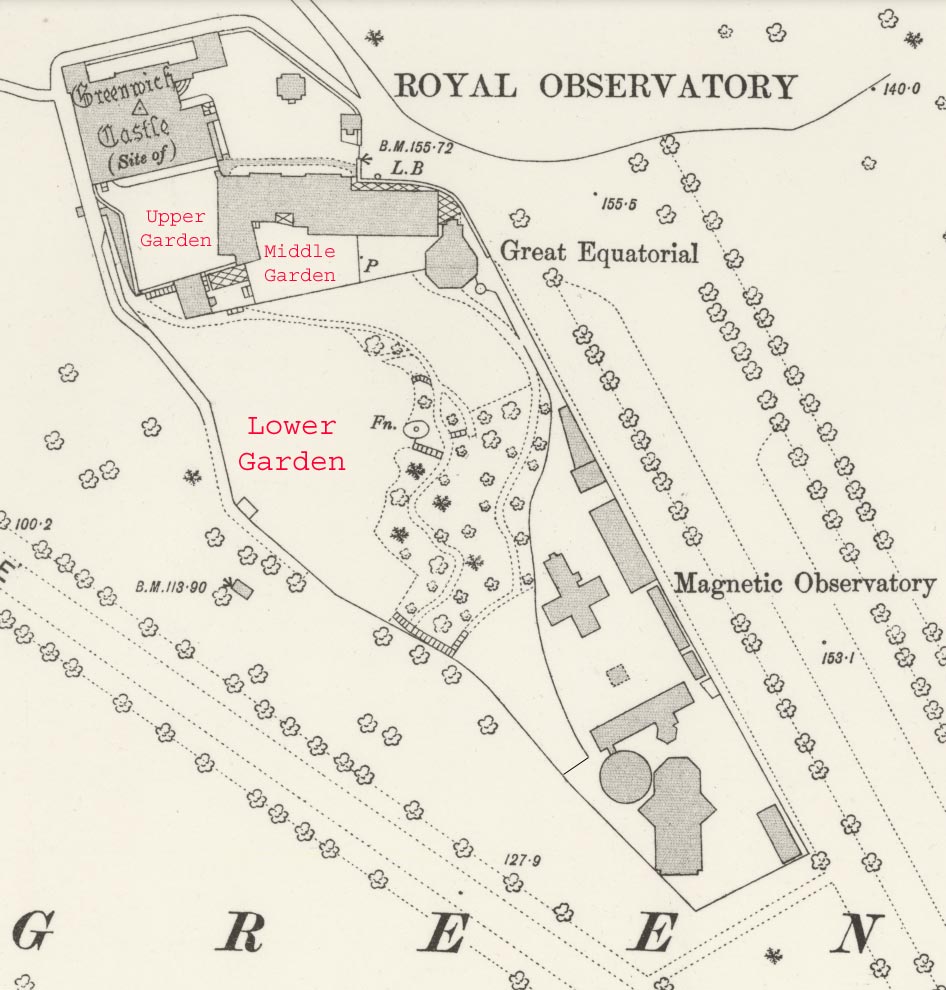
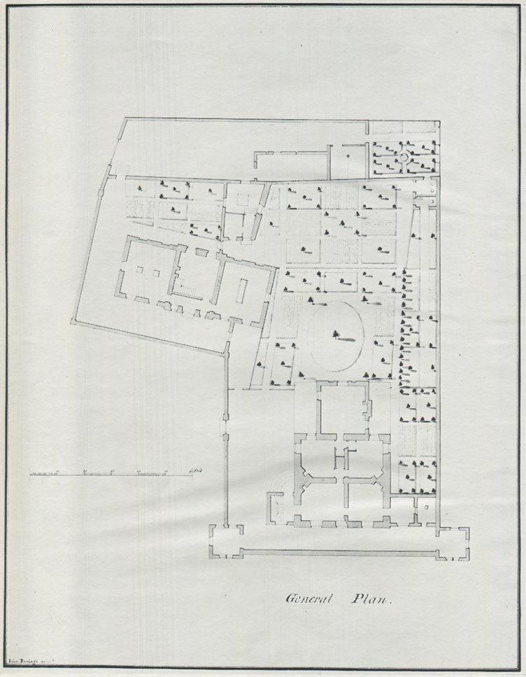
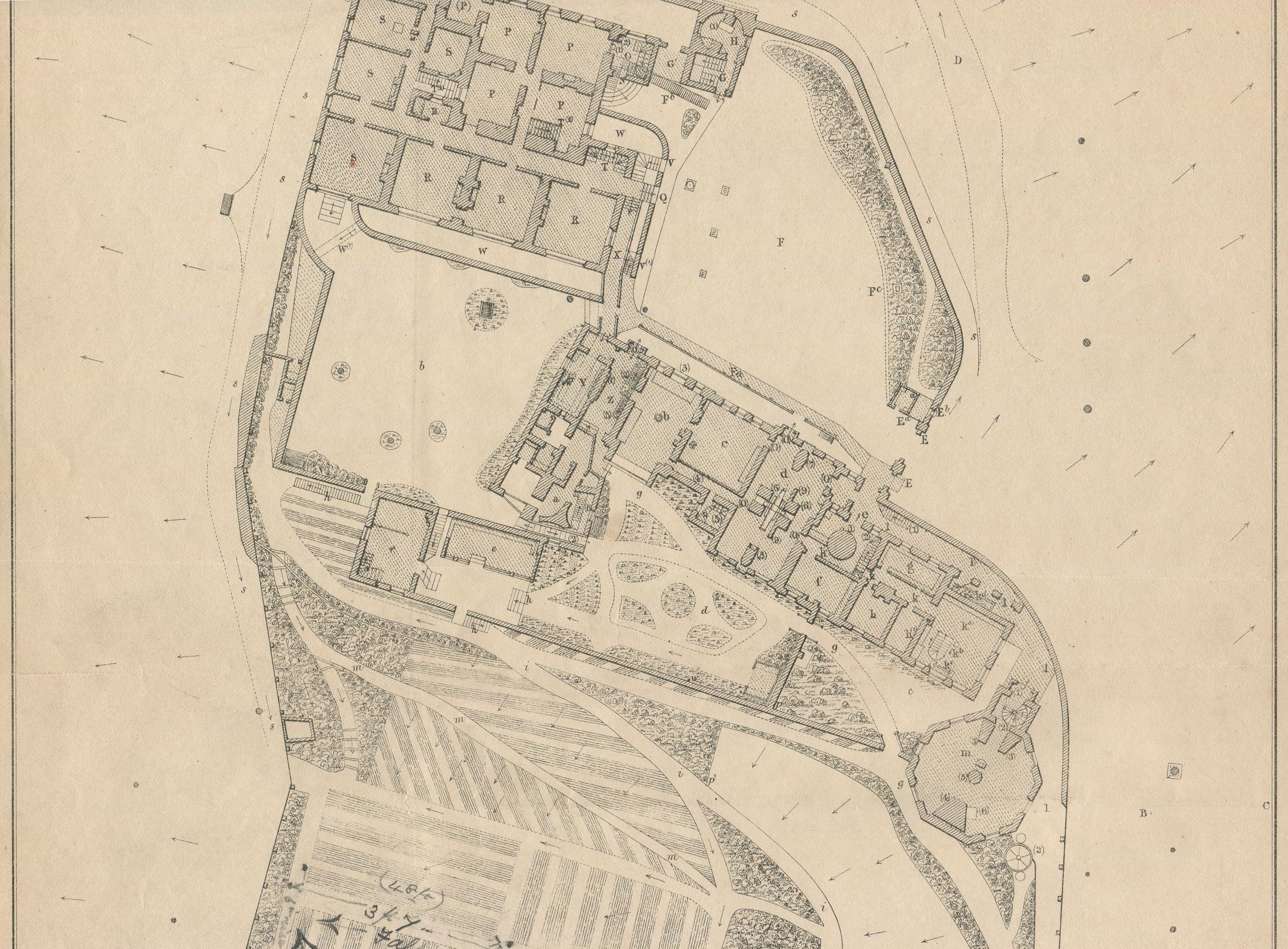
The Observatory site c.1894. The boundary of the Lower Garden, (which includes the slip of land to the west (left) of the Upper Garden), is marked with a solid line. Extract from the Ordnance Survey 25-inches to the mile map, revised 1893 to 1894 and published in 1897. Reproduced under the terms of a Creative Commons Attribution-NonCommercial-ShareAlike 4.0 International (CC BY-NC-SA 4.0) license courtesy of the National Library of Scotland (see below)
The Lower Garden in Flamsteed's time
The part of the Lower Garden which dates back to Flamsteed’s time is a small rectangular section measuring roughly 10 x 27 feet that was originally bounded by the retaining wall of the Upper Garden to the north, and the west wall of Flamsteed’s Garden House (later the site of the stables and now a plant room) to the east. Today this section is neither enclosed within the garden, nor within the curtilage of the Observatory. It forms instead a buffer zone between them and a path in the park. In Flamsteed’s time the only means of accessing this part of his garden was via the park.
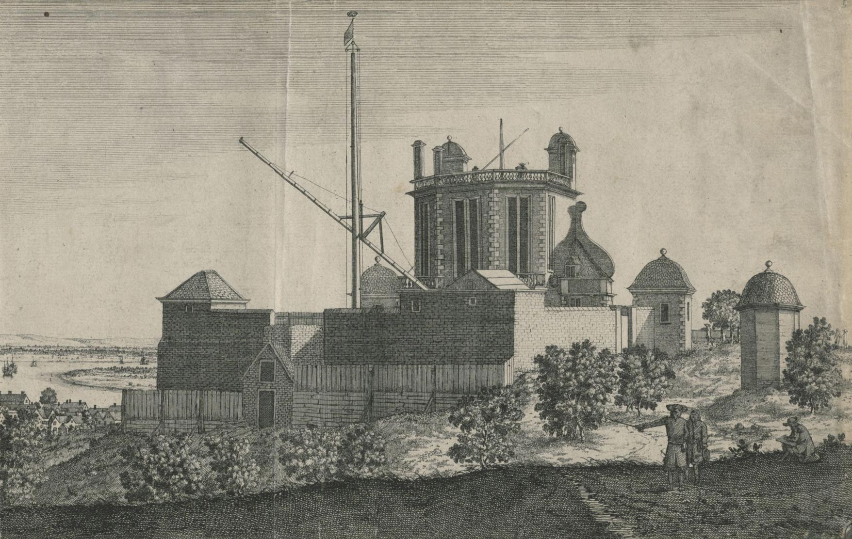
The Royal Observatory in Flamsteed's Time. The doorway (bottom left) was the entrance to Flamsteed's garden room / potting shed. The small fenced areas of garden on either side were extended slightly southwards in about 1749. The section on the right became part of the Middle Garden whilst that on the left became part of the Lower Garden when the ground where the figures are standing was enclosed in 1814. Etching by Francis Place after Robert Thacker c.1678 (detail), Digitised by the British Library and released under a Creative Commons Public Domain Mark (No Known Copyright). King George III collection, British Library shelfmark: Maps K.Top.17.1-3.a.1 (see below)
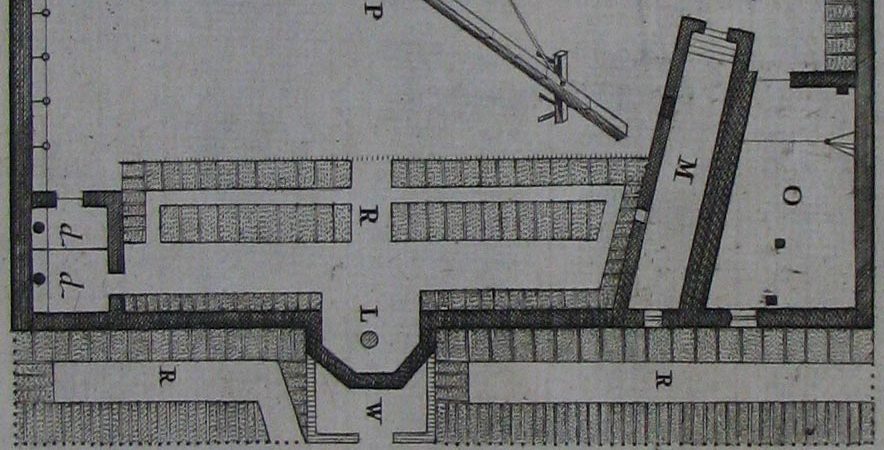
Plan showing the flowerbeds (R) behind the fence in the image above. Detail from an etching by Francis Place after Robert Thacker c.1678. Reproduced courtesy of Greenwich Heritage Centre
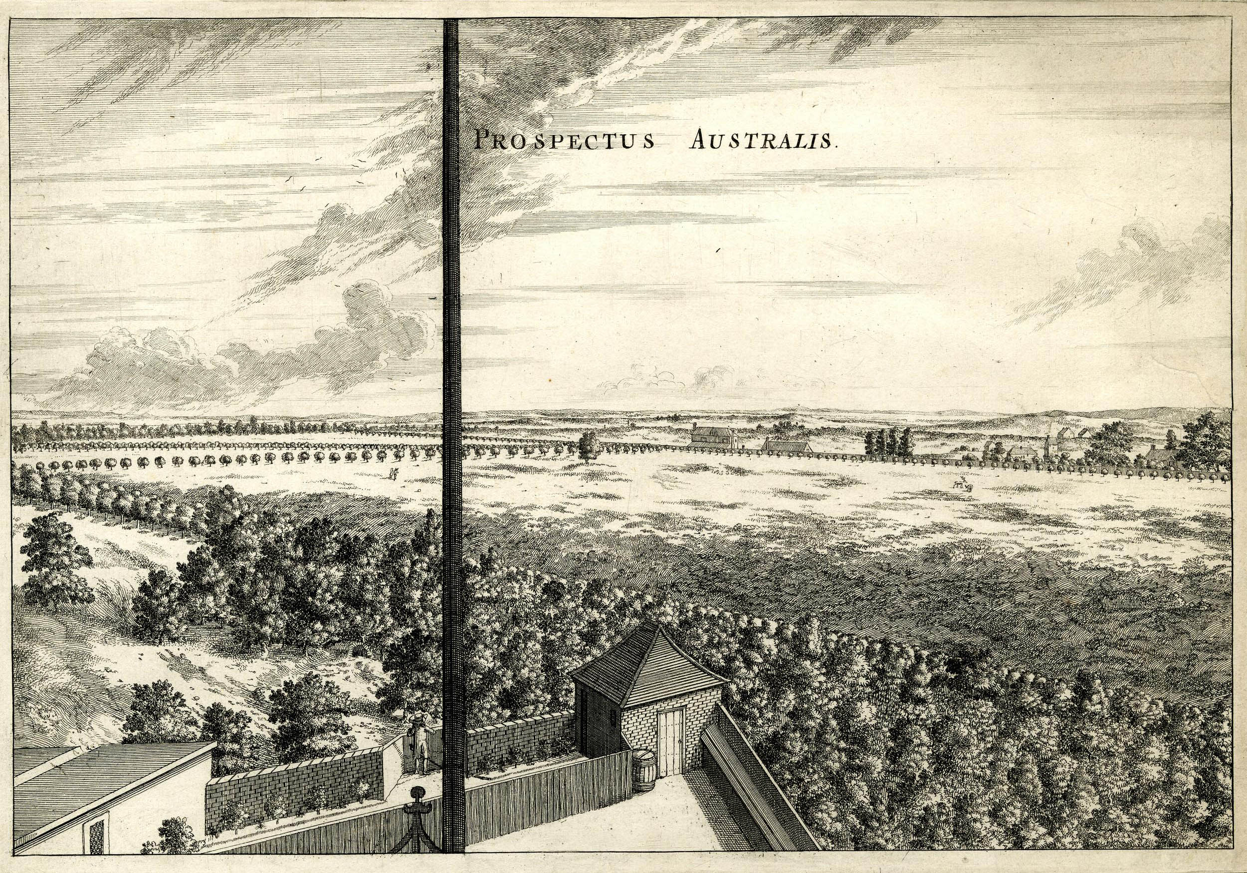
The view from the top of Flamsteed House looking southwards across the Park. The thick vertical line near the centre is the mast used to support the 60-foot telescope. The sloping area of ground to its left, beyond the boundary wall, is the area enclosed for the Observatory in two stages in 1814 and 1837. To the left of the mast, the Quadrant House can be seen and to the right, the Necessary House (toilet). Running from centre left to bottom right is an avenue of trees known today as The Avenue, but labelled on the Travers map of 1697 as Snow Hill Walk (TNA/MR1/253). The entrance to an ice-house, can be seen a little above and to the left of the figure standing behind the mast. It is possibly the one constructed for King James I in about 1620 and also referred to as a snow-house or snow conserve. Prospectus Australis, Etching by Francis Place after Robert Thacker c.1678. © The Trustees of the British Museum (CC BY-NC-SA 4.0). Museum number: 1865,0610.951 (see below)
A small extension for Bradley
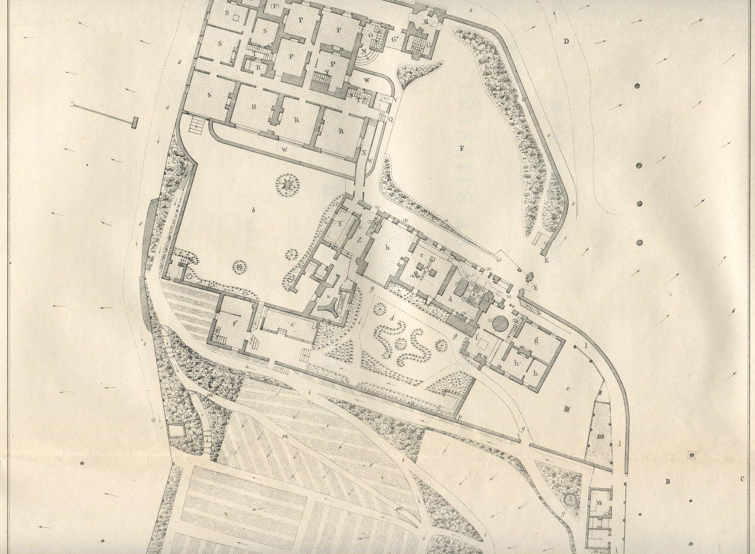
The plot was marginally deepened in a southerly direction, seemingly in 1749, at the time when the grounds were extended to enable Bradley to build his new Observatory (now part of the Meridian Building). These changes enabled the garden to be accessed from within the Observatory Grounds via an opening next to the newly built stables. The garden is shown in John Evelegh’s plan (below), but not in that drawn by Roy which was published in 1788.
John Evelegh's plan of the Observatory drawn between 1750 and 1773, with north at the bottom. When the grounds were extended for Bradley, the lower garden from Flamsteed's time was extended slightly southwards (upwards) to allow access to the new stables that appear to have been created from Flamsteed's garden room / potting shed. From a copy of the plan published in QJRAS in 1963
A new Kitchen Garden for the Astronomers Royal
The Lower Garden was considerably extended by John Pond in 1814 when about half the present garden was enclosed for use as a Kitchen Garden. It was extended southwards to its full size in 1837 at the same time that the Magnetic Ground was enclosed by Pond’s successor George Airy.
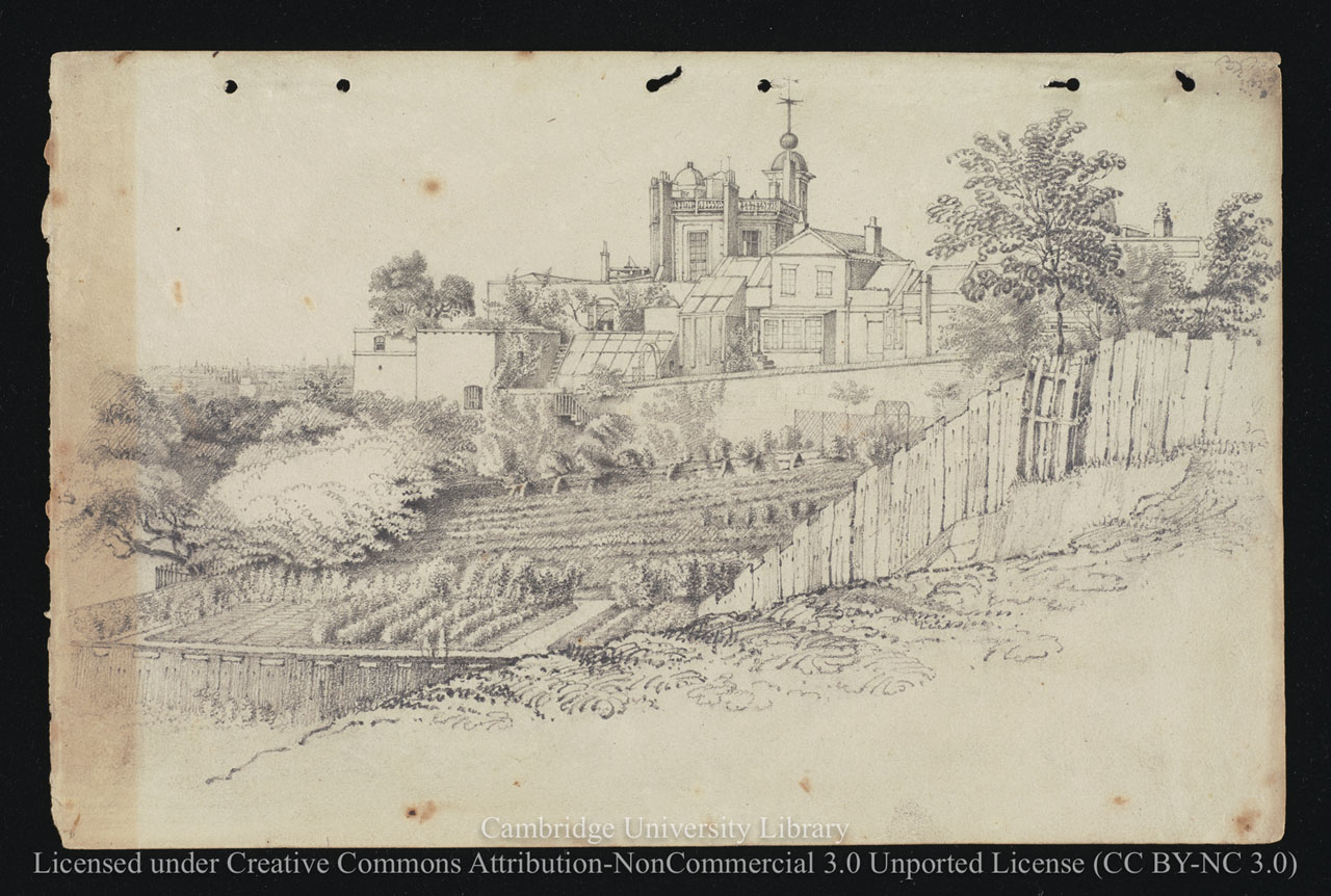
The Lower Garden from Greenwich Park before the southern part of the garden was enclosed. Pencil drawing by Airy's sister-in-law, Caroline Smith, 1836. Reproduced under the terms of a Creative Commons Attribution-Non-Commercial 3.0 Unported License (CC BY-NC 3.0) courtesy of Cambridge Digital Library (see below)
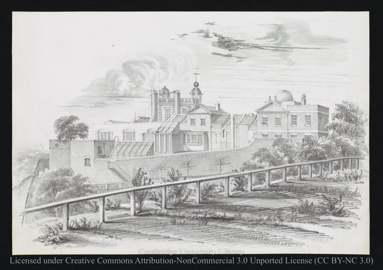
The same view drawn the year after the southern part of the garden was enclosed. Pencil drawing dated 28 May 1838 by Airy's sister-in-law, Elizabeth Smith. Reproduced under the terms of a Creative Commons Attribution-Non-Commercial 3.0 Unported License (CC BY-NC 3.0) courtesy of Cambridge Digital Library (see below)
Pond's well and Magnetic Observatory
In 1815, a well was dug close to the then southern boundary. Said to be 120 feet deep, the water proved bad and the well was covered in and a summerhouse built over the site after the garden was extended in 1837. The summerhouse was orientated to look back towards Flamsteed House, and in front of it, there was a small pond, which was probably created at the same time. At the extreme south end of the 1837 extension, Airy erected a second summerhouse. This survived until the 1890s when it was removed to allow the west wing of the South Building to be constructed, the summerhouse having occupied a spot near the wing’s north-western corner.
Meanwhile, in 1817, Pond had built his Magnetic Observatory near the well on the steep slope of the hill. The foundations gave way, causing the building to become dangerous. It was demolished in 1824.
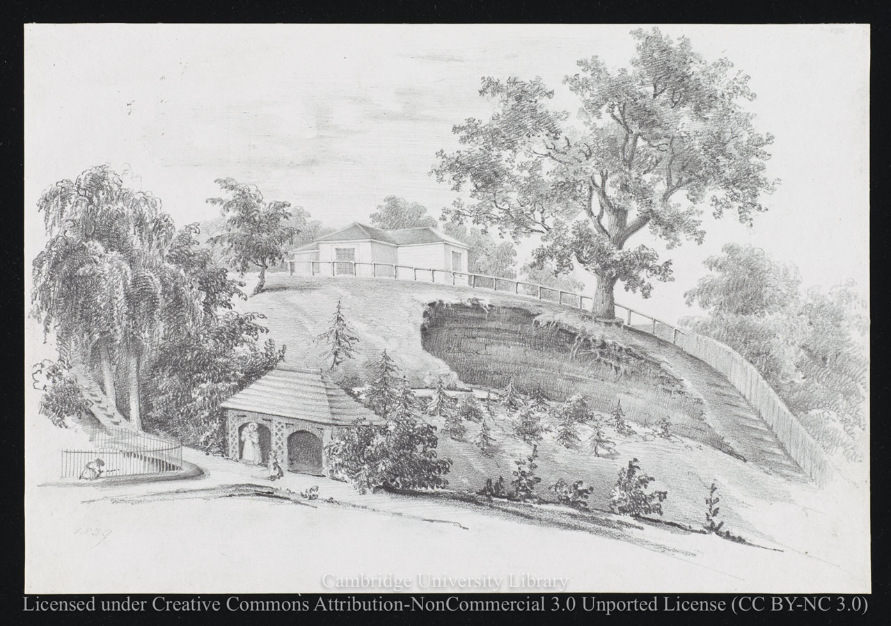
The view across the garden from the opposite direction to the two above. The building at the top is Airy's Magnetic Pavilion which was completed in the newly enclosed Magnetic Ground in 1838. The child (left) is playing beside the fenced off pond. The site of Pond's Magnetic Observatory was on the slopes at the top of the steps that can be seen above it, whilst the summerhouse sits on top of the well that was sunk in 1815. The oak tree with the seat around it was sometimes referred to as the Great Oak. The hole in the ground beneath it was caused by the past extraction of sand and gravel. Pencil drawing dated 1839 by Elizabeth Smith. Reproduced under the terms of a Creative Commons Attribution-Non-Commercial 3.0 Unported License (CC BY-NC 3.0) courtesy of Cambridge Digital Library (see below)
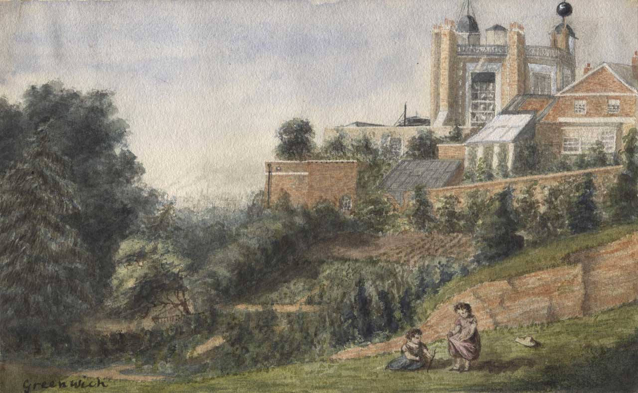
The Lower Garden from the south in about 1841–43. Watercolour painting by Henrietta Smythe. © The Scout Association Heritage Collection (see below)

The key difference between this picture and the one above is the appearance of the South Dome housing Airy's Altazimuth Telescope which was raised in 1844 on the walls of Maskelyne's Advanced Building (which itself had been built on the external walls of Flamsteed's Sextant House). Undated pencil drawing probably by Elizabeth Smith. Reproduced under the terms of a Creative Commons Attribution-Non-Commercial 3.0 Unported License (CC BY-NC 3.0) courtesy of Cambridge Digital Library (see below)
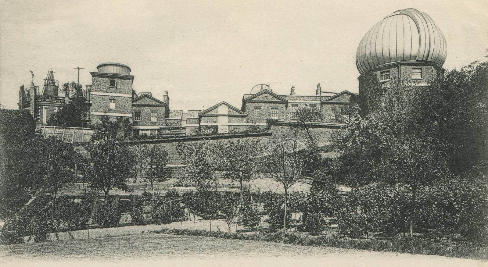
The Lower Garden in about 1893–97. From a postcard published by Edmund Düsédau
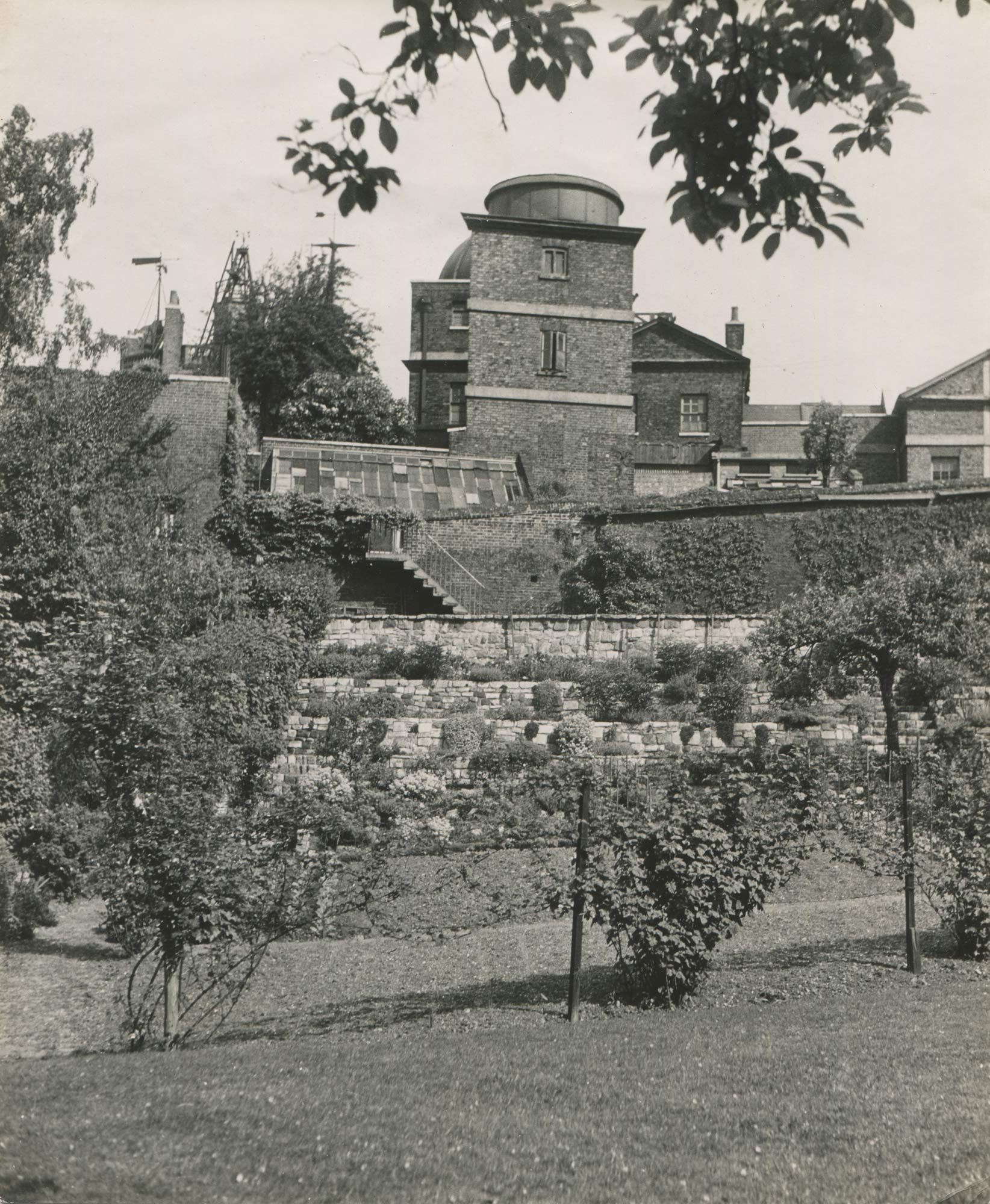
The garden in about 1944. The stone clad terraces are believed to have been created (and paid for) by Spencer Jones who became Astronomer Royal in 1933. To the right of the steps coming down from near the greenhouse, a row of espaliered fruit trees can be seen on the south facing retaining wall. Although the photographer is not recorded, it is thought to have been Cecil Beaton, who, at the request of the Ministry of Information, made a photographic survey of the Observatory and its departments in the reporting year 1944/5. Detail from Ministry of Information photograph D.24699, courtesy of Hillary Buckle
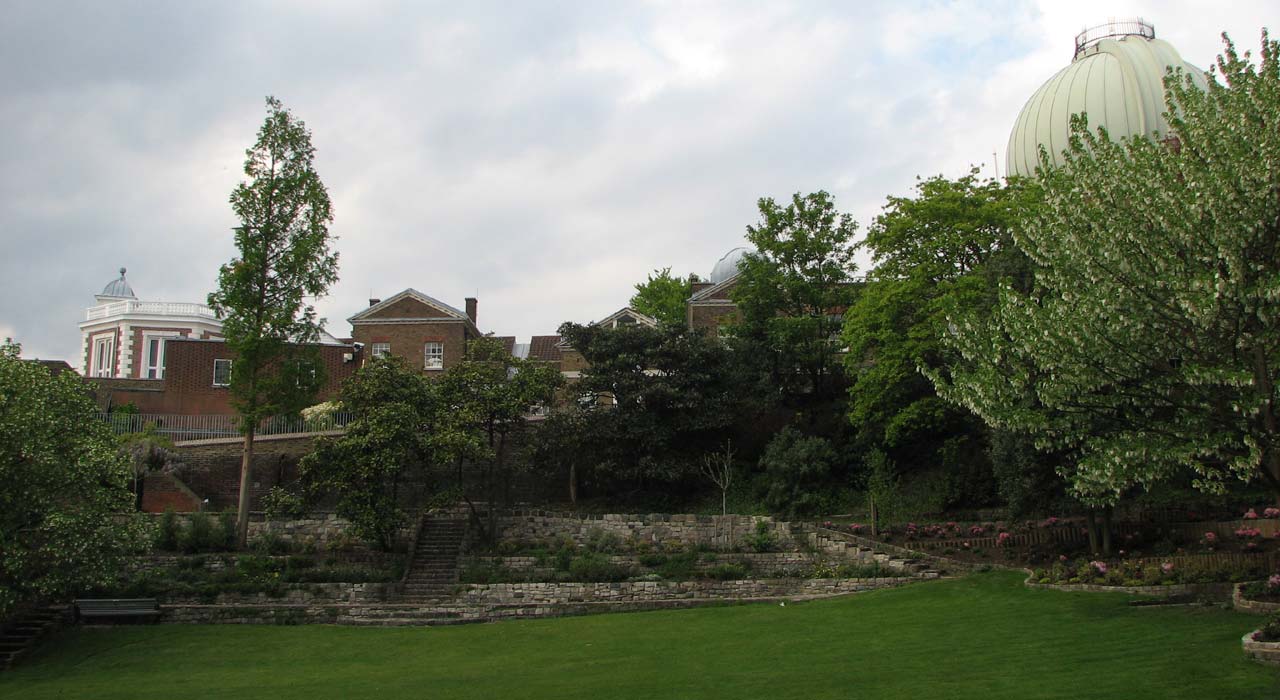
A similar view from May 2010
And in November 2017
The garden from the south west with the Great Equatorial Building behind in about 1930. The path in the Park between the railings and the fence was extended southwards in the second half of the 1890s to link it to the roadway in the Park that is now known as 'The Avenue'. The fence was sufficiently high to prevent the public from peering in. From a postcard published by the Royal Observatory, Greenwich
Access to the gardens
Access to the lower garden was always rather tricky. In Pond’s time, the only way to get to it was from the Drying Ground via a gap in the wall that had been created close to where the Great Equatorial Building was later built.
Airy’s arrival at the Observatory in 1835 saw the creation of two more points of access – both starting from the lawn immediately to the south of Flamsteed House. The first was a flight of steps that ran down the side of the retaining wall on the western side of the lawn from a point close to the French windows of the new extension. The second was via two sets of steps accessed from the southern end of the lawn and can be clearly seen in Elizabeth Smith’s 1838 drawing (above). The first descended to the to the lower part of the Middle Garden and ran down the eastern side of the stable wall. The second descended from there down to the Lower Garden.
Detail from the 1847 plan published in the 1845 volume of Greenwich Observations. Note the steps running from the Upper to the Lower Garden at the top of the slip of land to the west of the Upper Garden. They can just be made out in the image below
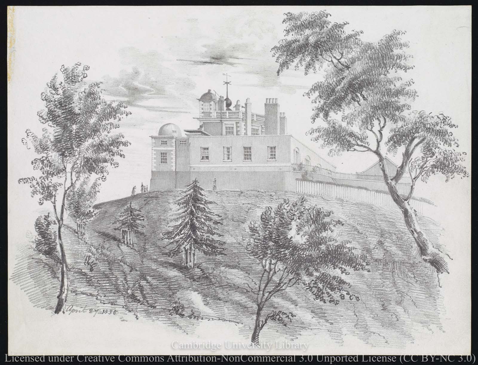
The Observatory from the west in 1838. The slip of the Lower Garden to the west of the Upper Garden is hidden between the fence and the wall on the right. The steps leading down to it from close to Flamsteed House can just be made out against the retaining wall of the Upper Garden. Pencil drawing dated 27 April 1838 by Elizabeth Smith. Reproduced under the terms of a Creative Commons Attribution-Non-Commercial 3.0 Unported License (CC BY-NC 3.0) courtesy of Cambridge Digital Library (see below)
Between 1847 and 1863, Airy relocated the two toilets in the south east corner of the lawn outside Flamsteed House to the slip of land to the west of its retaining wall where they now blocked the access to the Lower Garden from the steps near the French windows. One of the new toilets was accessible from the Lower Garden. The other was accessed not via the steps of 1835, which were removed, but from the basement area of Flamsteed House via a newly created subterranean passage. At the same time, a new access point was created from the south end of the lawn, but this time via a new set of steps that ran down the south side of the retaining wall from a point immediately to the west of the stables.
Both the toilets and this latest set of steps were removed in Christie’s time when the part of the garden they both lead to was planted over with shrubs as part of a landscaping scheme orchestrated as part of a general improvement of the Park in this vicinity. The toilets appear to have been removed in 1894/5 and the steps at some point after 1896 (they are not shown on the plan updated to 1911). As a result, the only way that the garden could then be approached was via the Meridian Garden or the Drying Ground.
When the gardens were returned to the Royal Park the two surviving entry points from the rest of the Observatory site were blocked off and a new entry point created from the path that runs along its western edge. This was brought into use in about 1960.
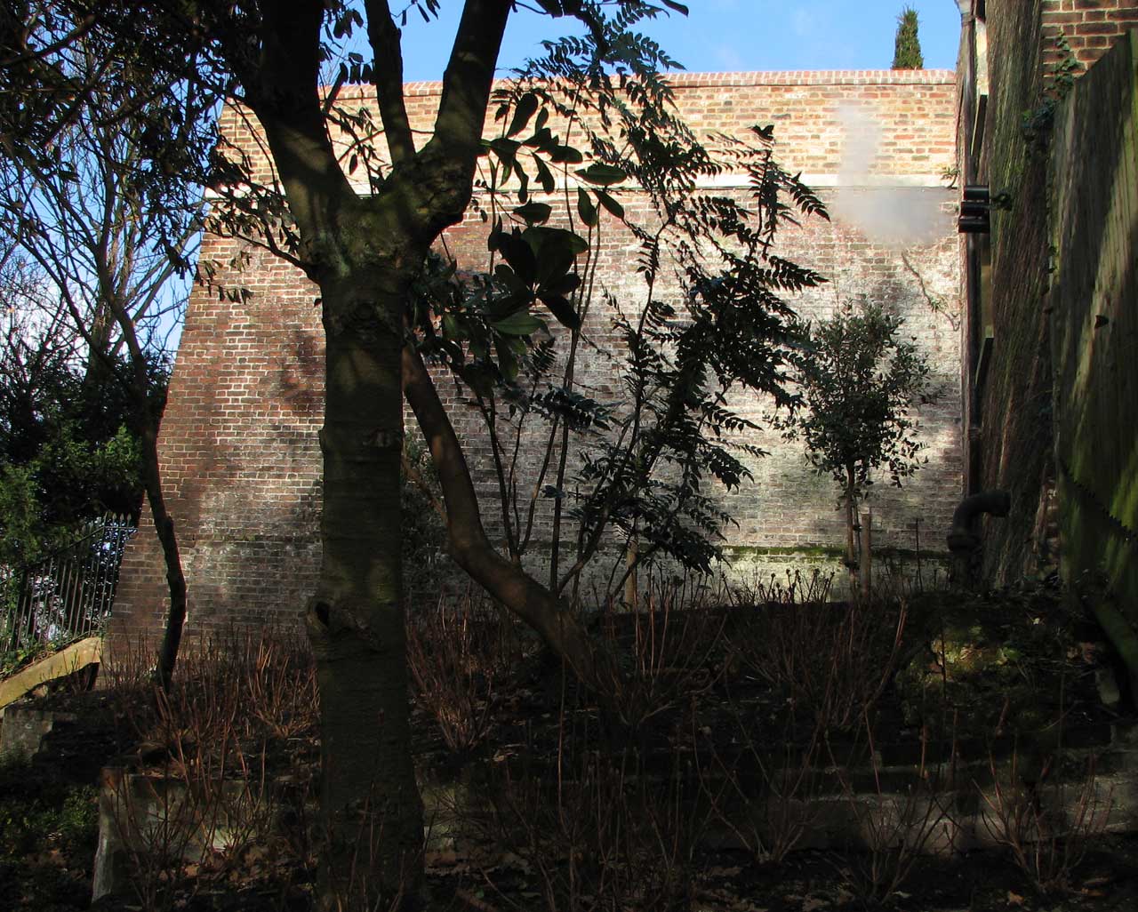
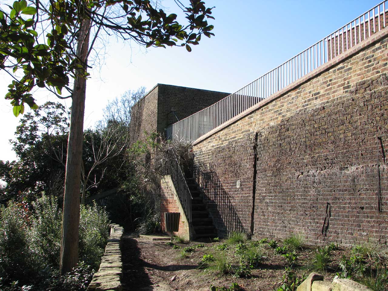
The steps removed in Christie's time were accessed though an opening (now closed) at the top of the sunlit wall. They ran from top right to bottom left. The opening was originally blocked up with railings, but these were unfortunately removed in the second half of 2009 when the whole of the wall above the string line was rebuilt. Photo: January 2012
The view from the top of the wall. The railings (centre) mark the point where the steps descended from the Upper Garden (Astronomer's Garden) to the Lower Garden. When the top of the wall was rebuilt not long after the photo was taken, two historic features were regrettably lost. Firstly, the opening was bricked up and the railings removed. Secondly, the capping stones on the top of the wall (which had existed in some form or other since Flamsteed's time) were replaced by sloping brickwork similar to that which had been introduced on the wall leading down to the stables in the eighteenth century. Photo: April 2009
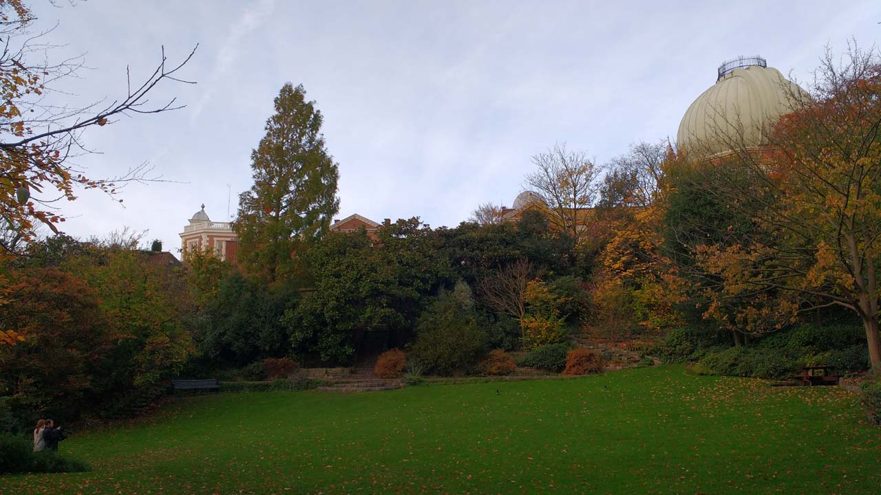
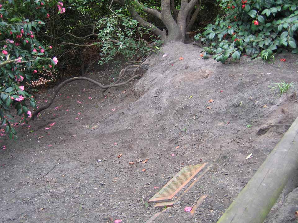
Looking south-eastwards across the garden from near to where visitors enter it today. Pond's Magnetic Observatory was on the sloping area now covered in trees to the left of the Altazimuth Pavilion. The Pavilion, along with the other buildings on the east side of the garden, can only be seen in the winter months when the leaves are off the trees. Photo: March 2009
The network of pathways
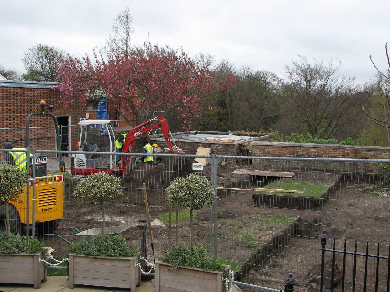
The pathways along the eastern slopes date back to the time of Airy. From time to time, they have required rebuilding, as they are prone to slippage and erosion. On one such occasion, the damaged terracotta from the bombing of the Altazimuth Pavilion in WW2 was used as edging support. They were visible until the paths were reconstructed during a major refurbishment of the gardens in 2008/9 though some pieces have since re-emerged.
Some of the dumped terracotta from the Altazimuth Pavilion supporting one of the upper pathways in April 2006
The exotic fruit trees
The retaining wall between the middle and lower gardens is south facing and of sufficient height to support the growth of exotic fruit trees. In the 1940s, there were three varieties of peach growing there: Rivers Early York, Noblesse and Royal George, along with the nectarine Elruge. During WW2 when much of the Park was turned over to allotments the garden continued to be cultivated, the produce being sent to the Astronomer Royal’s evacuation residence in Abinger. Although the trees have long since gone, the lead name tags are still fastened to the wall.
The top of the south facing wall was rebuilt in 2009, which is when these particular railings were added. Although the four espaliered trees had long since been removed, their lead name plates were still present on the wall in 2017. One can be seen a few course above the ground on the right side of the wall. The others are out of sight to the right. In order from right to left, the four trees were: Peach (Rivers Early York), Peach (Noblesse), Nectarine (Elruge), Peach (Royal George). The four labels can be seen below. Photo: March 2011
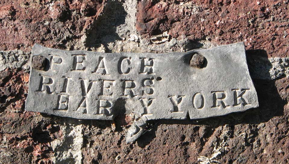
Photo: March 2011
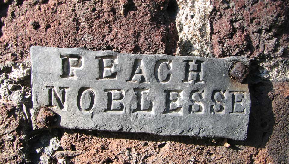
Photo: March 2011
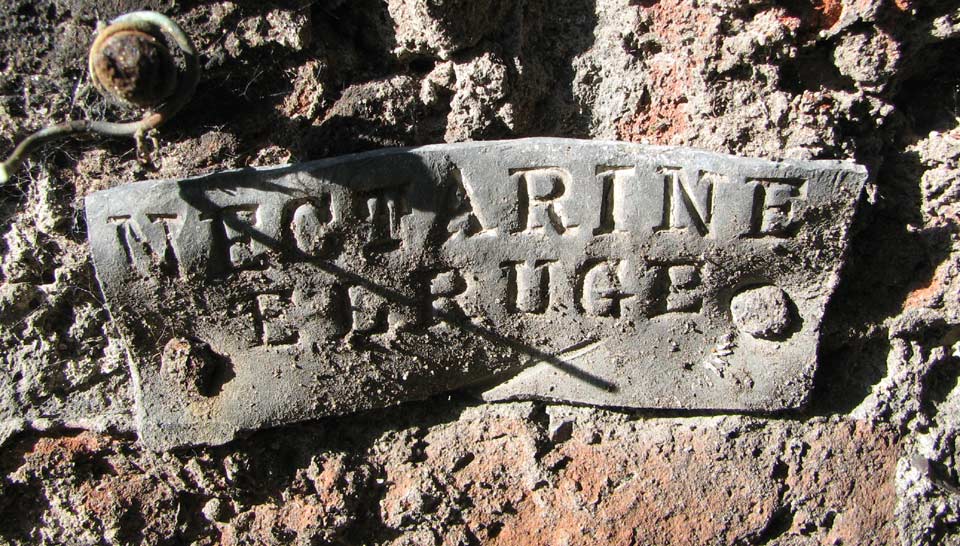
Photo: March 2011
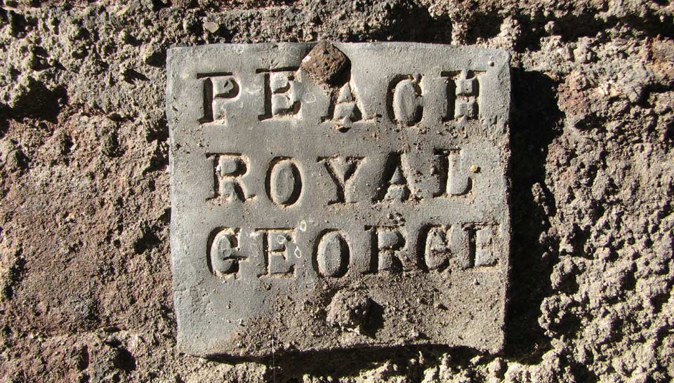
Photo: March 2011
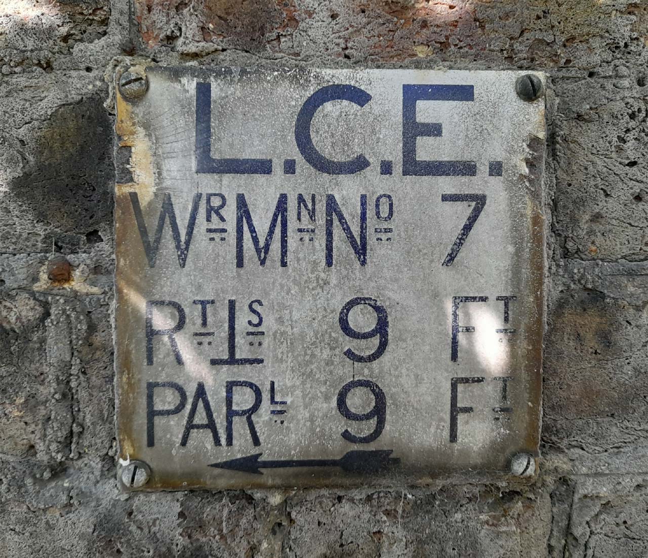
Sign indicating the location of the nearby fire hydrant. Mounted on the same wall as the labels above, it was one of a number of such signs erected around the Observatory. They are believed to date from around 1901. Photo: March 2022
The levelling of the lawn at the bottom of the slope (for a tennis court?) and more about the ice-house
Today, much of the garden is laid to lawn with the lower area having been levelled. This levelling appears to have happened when Dyson became the new Astronomer Royal in 1910 and seems to have involved building a retaining wall at the bottom of the slope and building up the ground level. A rectangular area marked in pencil on a copy of the published 1863 Observatory Plan suggests that he was exploring how he might create a tennis court.
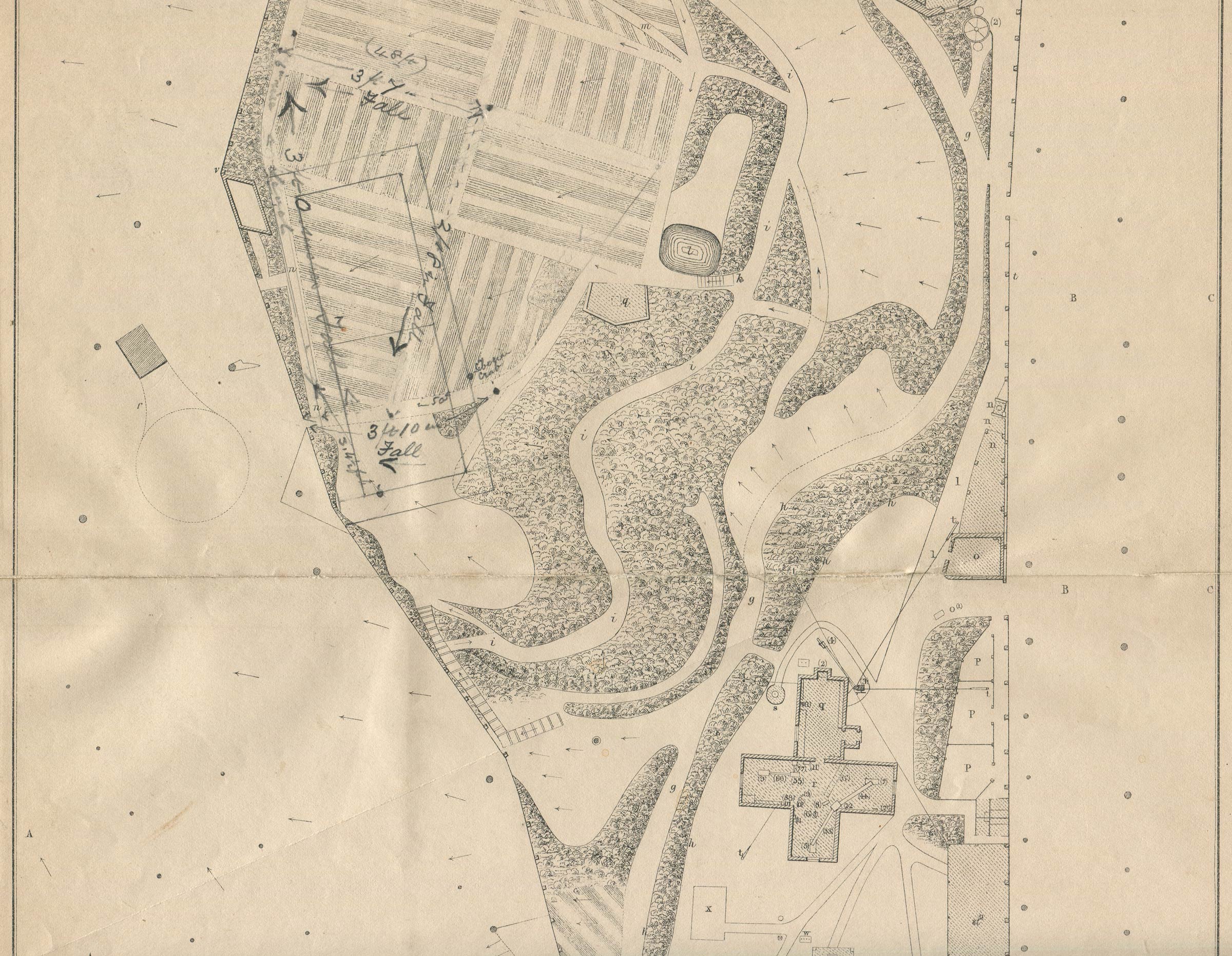
Detail from the 1863 plan published in the 1862 volume of Greenwich Observations. It shows what appears to be a proposal by Dyson for leveling the lowest section of the garden to create a tennis court. The dimensions of the outer rectangle are roughly 81 x 43 feet. That of the inner are 69 x 25 feet. The work appears to have taken place soon after Dyson's arrival as Astronomer Royal in 1910 as the present brick retaining wall on the west side first appears on the 1911 Admiralty map of the grounds. The feature to the left of the proposed court (looking a bit like a table tennis bat) was marked by Airy as 'An Ice-house, belonging to the house of the Ranger of Greenwich Park'. The circular section has a diameter of about 30 feet. On the earlier plan from 1847, Airy labelled it slightly differently calling it 'An ice-house, belonging to the Ranger's House'. The entrance appears in the c.1678 Francis Place etching reproduced above
On 30 May 1860, Airy wrote to the Chief Commissioner of Parks about the problems he was having with ‘boys and idle people’ climbing the mound which covered the well of the ice house and throwing stones into his garden despite the fact that he had raised the fence in the vicinity. He went on to ask if a fence of palings could be erected either round the base of the mound or half-way up it, and fitted with spikes and tenter hooks (angled spikes) to prevent people from climbing over it. Although steps were taken to allieviate the problem; instead of taking up Airy’s suggestion, thorn and briar stakes were driven into the top of the mound and a sign erected cautioning the public against throwing stones in the Park (RGO6/49). The stakes appear to have had the desired effect, but clearly needed a degree of maintenance as on 27 March of the following year Airy wrote again asking if ‘the thorn defence’ could be reinstated and preferably before Easter Day. The urgency is interesting as it suggests that many people still came to Greenwich at Easter, despite the fact that the notorious Greenwich Fair, which had traditionally begun on Easter Monday, had been banned after the fair of 1857.
Further details regarding the ice-house can be found on this page of the website.
Aborted plans for an underground meridian mark
The following text has been taken from the 1915 Report of the Astronomer Royal to the Board of Visitors and relates to a test boring that were made to see if the geology of the garden was suitable for constructing an underground meridian mark for use with the Airy Transit Circle – the telescope that defines the Greenwich Meridian.
‘In view of the success which has attended the underground meridian marks at the Cape Observatory, borings were made [on the line of the Meridian] just outside the S. collimator of the transit circle, and at the end of the Astronomer Royal's garden. The first of these was stopped at a depth of 37 feet after passing through 29 feet of very hard compact ballast. Throughout the last 24 feet it was necessary to use chisels almost continuously before the core could be removed with an augur. It was considered that this formation was very suitable for the construction of a collimator pit of relatively shallow depth. The boring in the garden, which is about 40 feet below the level of the ground near the transit circle, indicated an entirely different formation. The bore was sunk to a depth of 58 feet in 8 days, the last 42 feet being in very fine dry sand. In consultation with the Civil Engineer the conclusion was reached that it was useless to proceed further, as absolute stability of a mark could not be anticipated, especially as a well shaft would form a channel by which surface water could reach and probably disturb the sand.’
Although it is not clear quite where Dyson meant when he said the boring had been made ‘at the end of the Astronomer Royal’s garden’, the bore hole was probably just before or after the tennis court and within about 60 feet of the structure identified by Airy as an ice-house. If the ground on which the ice-house was built had the same geological profile, it would support the idea that the structure was indeed an ice-house rather than one of the many conduit heads in the Park that had once supplied water to the Royal Palace at the bottom of the hill.
A problem with security
When the Royal Observatory left Greenwich for Hertmonceux in 1957, the garden was reabsorbed into the parl and formally opened to the public by the Queen during her visit to open Flamsteed House in 1960, access being from the path running along its south-west boarder. In 1960 howver, there was no fence separating the garden from the South Ground where the Altazimuth and South Buildings were located. Security issues forced the garden’s closure in the 1970s, pending the erection of a suitable fence. It reopened in 1978.
Image licensing information
The Ordnance Survey map extract (modified) is reproduced under a Creative Commons Attribution-NonCommercial-ShareAlike 4.0 International (CC BY-NC-SA 4.0) licence courtesy of the National Library of Scotland. Click here for the complete map.
The images reproduced courtesy of Cambridge Digital Library have been reduced in size and are more compressed than the originals and have been reproduced under the terms of a Creative Commons Attribution-NonCommercial 3.0 Unported License. Some have also had their boarders cropped. Links to the individual images are as follows: image 1, image 2, image 3, image 4, image 5.
The first Francis Place image is reproduced courtesy of the British Library under a Creative Commons Public Domain Mark (No Known Copyright). King George III collection, British Library shelfmark: Maps K.Top.17.1-3.a.1. Link to image as released on Flickr.
The image from the British Museum is reproduced under an Attribution-NonCommercial-ShareAlike 4.0 International (CC BY-NC-SA 4.0) license, courtesy of the The Trustees of the British Museum. It has been cropped and recompressed for this website. Original image, British Museum number: 1865,0610.951.
The painting by Henrietta Smythe is reproduced by kind permission of The Scout Association Heritage Collection. Henrietta Grace Smythe (1824–1914) was the sixth of eleven children born to Captain (later Admiral) William Henry Smythe (1788–1865), a distinguished astronomer, fellow of the Royal Society and a member of the Observatory’s Board of Visitors from 1836 until his death. One of Henrietta’s two older brothers, Charles Piazzi Smyth (1819-1900), became Astronomer Royal for Scotland in 1846. The other, Warrington Wilkinson Smythe (1817–90), married Anna Storey Maskelyne, granddaughter of the fifth Astronomer Royal Nevil Maskelyne. In 1846, Henrietta married Baden Powell, the Savilian Professor of Geometry at Oxford who was 28 years her senior and previously twice married. Widowed in 1860 shortly after the birth of her tenth child, she changed the family name to Baden-Powell. Her son Robert was the founder of the Scout Movement.
© 2014 – 2026 Graham Dolan
Except where indicated, all text and images are the copyright of Graham Dolan