…where east meets west
- Home
- Brief History
- The Greenwich Meridian
- Greenwich
(1675–1958) - Herstmonceux
(1948–1990) - Cambridge
(1990–1998) - Outstations (1822–1971)…
- – Chingford (1822–1924)
- – Deal
(1864–1927) - – Abinger
(1923–1957) - – Bristol & Bradford on Avon
(1939–1948) - – Bath
(1939–1949) - – Hartland
(1955–1967) - – Cape of Good Hope
(1959–1971)
- Administration…
- – Funding
- – Governance
- – Inventories
- – Pay
- – Regulations
- – Royal Warrants
- Contemporary Accounts
- People
- Publications
- Science
- Technology
- Telescopes
- Chronometers
- Clocks & Time
- Board of Longitude
- Libraries & Archives
- Visit
- Search
Aerial Views (Greenwich)
The site of the Royal Observatory at Greenwich grew in size as the years went by to accommodate the changing needs of the Astronomers Royal. This was achieved by enclosing tranches of land from Greenwich Park. Thirteen such enclosures took place, ranging in size from just a few a square metres to about an acre.
By the 1940s when the Observatory came to move to Herstmonceux, its land holding at Greenwich was 3.36 acres or 1.81% of the Park. The main site occupied 2.46 acres, whilst the smaller Christie enclosure of 1897 (located some 400 metres to the east of Flamsteed House) occupied the rest. The Christie enclosure and part of the gardens on the main site were returned to the Park in 1959/60.
The main site in the early 1900s
Although published in 1913, this annotated view of the main site as seen from the north, appears to show the buildings in the state they were in between about 1900 and 1907. Although there is a slight misplacement and misorientation of some elements, the drawing gives a good impression of how the site appeared at that time.
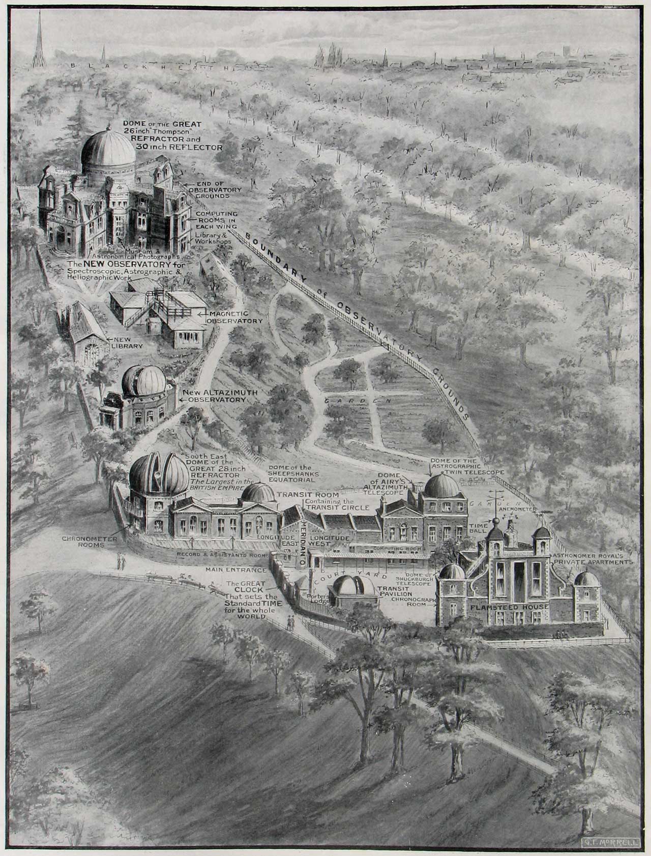
Diagrammatic view of the principal buildings on the main Observatory site. Drawn by G F Morrell and published in The Graphic on 7 June 1913
Photos from the 1920s
The main difference between these two images and the one above is the absence of the Magnetic Observatory which was demolished in 1918. As well as the main site, the second photo also includes the Christie enclosure which can be seen at the top of the image. When the photograph was taken, it contained just two buildings, The Magnetic Pavilion in the centre (erected in 1899) and the Magnetograph House to its left (erected in 1914).
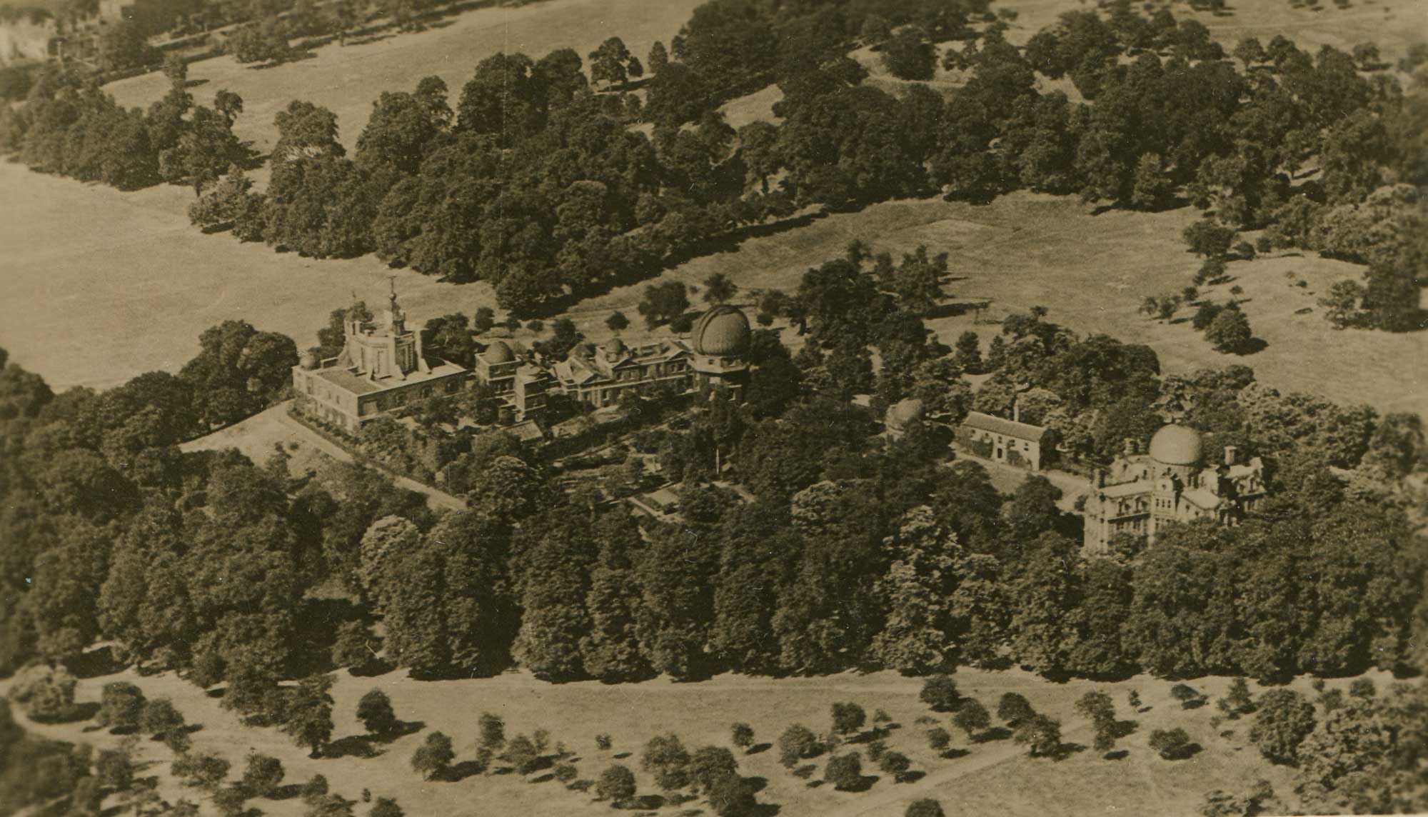
From a postcard (SFS Series, No.1596)
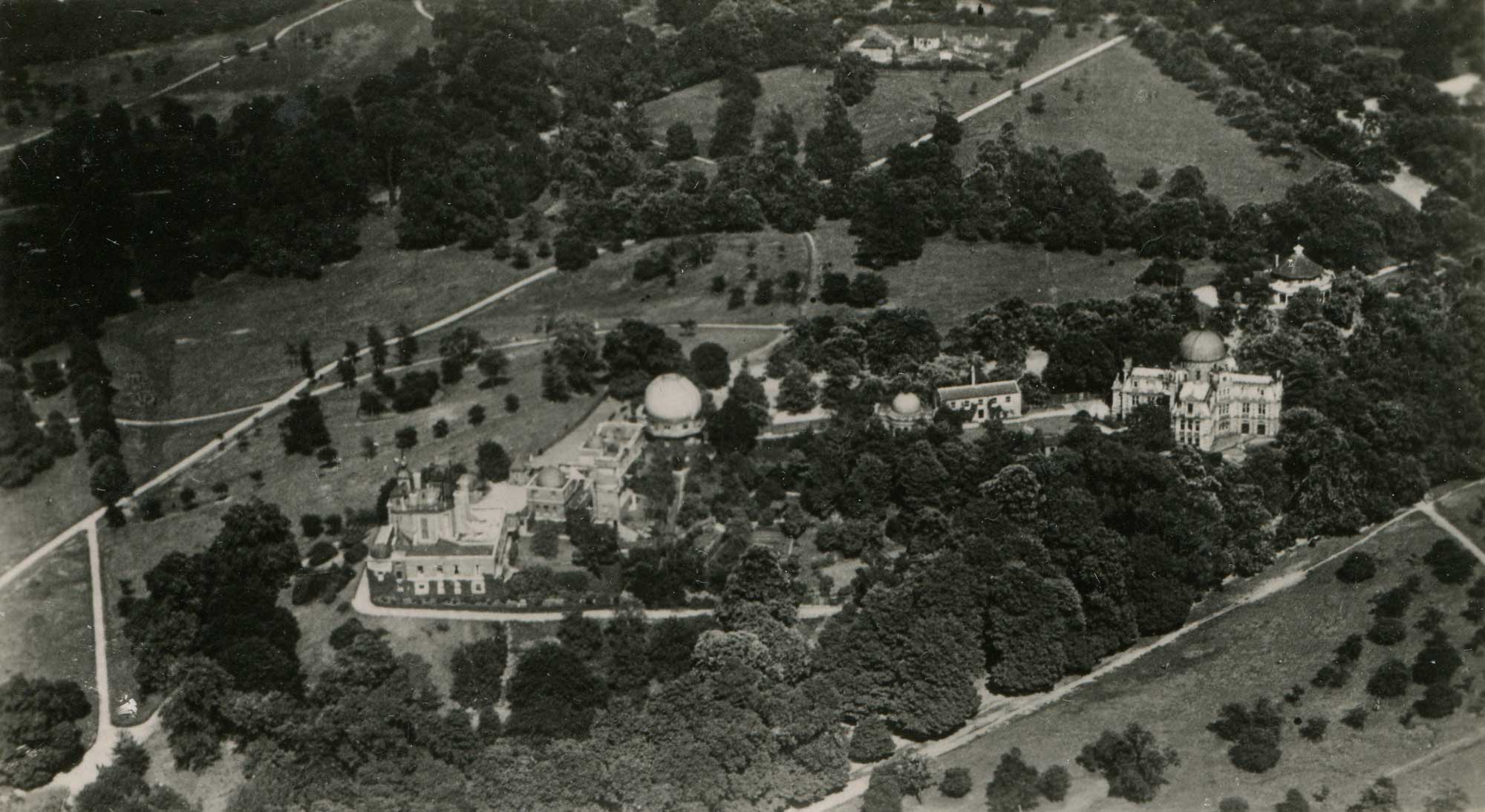
From a postcard (Central Aerophoto Co. Ltd., No.2615)
Photos taken by Aerofilms in the 1924, 1946 and 1948
Founded in 1919, Aerofilms Ltd had taken more than 760,000 oblique aerial views of Britain by 2006. In 2007, the image collection was purchased by a partnership of English Heritage (now Historic England) and the Royal Commission on the Ancient and Historical Monuments of Scotland (now Historic Environment Scotland) and the Royal Commission on the Ancient and Historical Monuments of Wales (RCAHMW). Many of them have been digitised and can be viewed on the Britain from above website and the Historic England website. The following images show the Observatory:
1924, view from the north (Photo - EPW010756)
1946, view from the south-east (Photo - EAW002293)
1948, view from the west (Photo - EAW016232)
1948, view from the north-west (Photo - EAW016233)
1948, view from the north (Photo - EAW016224)
The observatory in about 1954
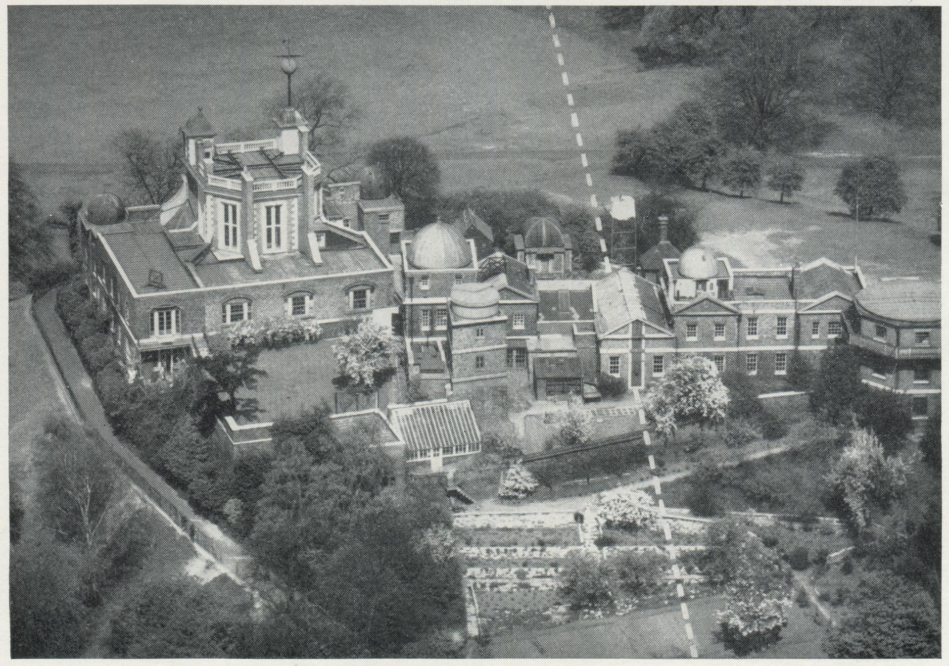
From a photo by Photoflight Ltd.
This image, which dates from about 1954, captures the site during the brief period while the Time Department was still on site but the Octagon Room was open to the public under the management of the National Maritime Museum. The dotted white line represents the Prime Meridian as defined by the Airy Transit Circle. The image gives a clear view of the rear of the buildings as well as the gardens of which there are relatively few other images from any period.
By 1954, the damage caused during World War 2 had been patched up and the buildings made secure and watertight. The anemometers have been removed from the Octagon Room roof and the rolled steel joists installed in their place to support the ceiling below by means of straps and bolts passing through the lead flats can be clearly seen (they were subsequently removed during later renovations in the early 1990s). On the extreme right, the badly damaged dome of the Great Equatorial Building has been removed following the removal of the 28-inch refractor to Herstmonceux in 1947 and the building capped pending further decisions on its future.
Of particular interest is the small southwards extension of the Meridian Building just to the left of the Prime Meridian. Little is known about it other than that it was a built as a 'concrete housing for the new time desk and terminal frame' that had been 'erected on the site of the cold greenhouse; a new greenhouse having been erected' adjoining it (which can be seen in front of it in the photo).
Also of interest, but not yet identified is the structure that has appeared on the south-west corner of the roof of Flamsteed House.
Photos from the twenty-first century
During the Observatory’s conversion to a museum in the 1950s and 60s, many buildings were demolished and many of the extensions and chimneys removed. In the early 2000s, the Peter Harrison Planetarium was built on the site of the former Magnetic Observatory. Clad in bronze and glass, it was opened by the Queen on 22 May 2007.
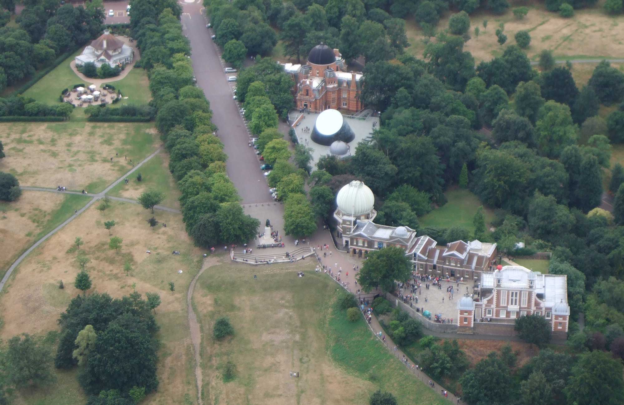
8 August 2008. The Observatory from the North. Photo courtesy of The Greenwich Phantom
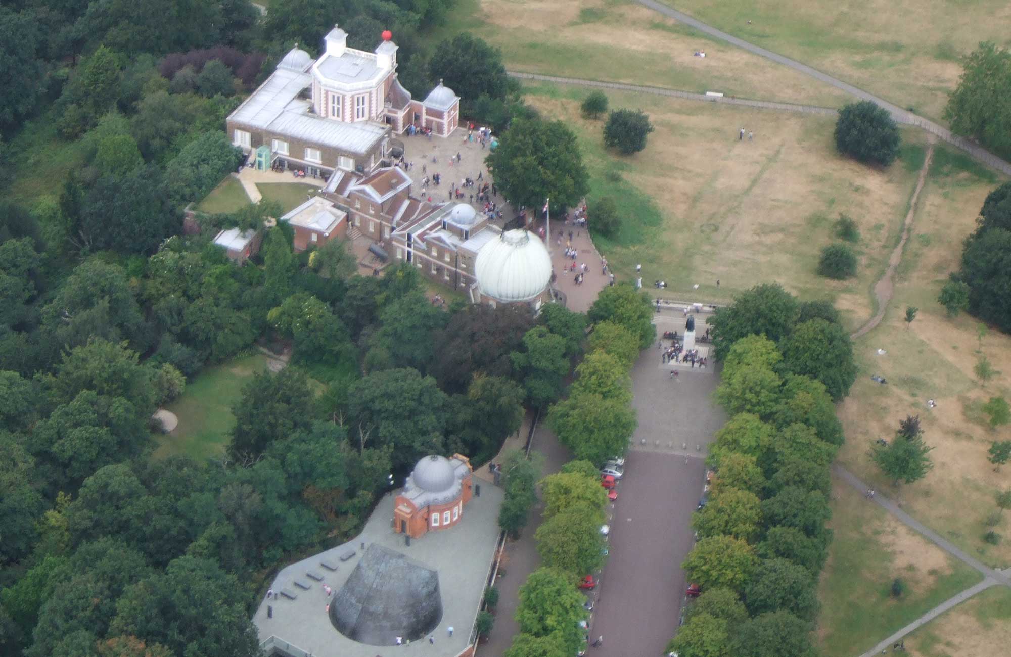
8 August 2008. The Observatory from the South. The Peter Harrison Planetarium can be seen at the bottom of the photo. Photo courtesy of The Greenwich Phantom
Other aerial views
Recent aerial views of the site can be found on Google Maps and Bing Maps. The following postcode should be used: SE10 8XJ.
Both allow the viewer to see bird’s eye views from different directions.
The aerial views on Google Earth have two big advantages over those on Google Maps.
- The aerial views are available at a higher resolution.
- A sequence of historical images back to 2003 can also be viewed.
© 2014 – 2026 Graham Dolan
Except where indicated, all text and images are the copyright of Graham Dolan