…where east meets west
- Home
- Brief History
- The Greenwich Meridian
- Greenwich
(1675–1958) - Herstmonceux
(1948–1990) - Cambridge
(1990–1998) - Outstations (1822–1971)…
- – Chingford (1822–1924)
- – Deal
(1864–1927) - – Abinger
(1923–1957) - – Bristol & Bradford on Avon
(1939–1948) - – Bath
(1939–1949) - – Hartland
(1955–1967) - – Cape of Good Hope
(1959–1971)
- Administration…
- – Funding
- – Governance
- – Inventories
- – Pay
- – Regulations
- – Royal Warrants
- Contemporary Accounts
- People
- Publications
- Science
- Technology
- Telescopes
- Chronometers
- Clocks & Time
- Board of Longitude
- Libraries & Archives
- Visit
- Search
Historic plans of Greenwich Park: an illustrated catalogue
page under construction
Although originally enclosed as long ago as 1443, the earliest known plan that shows all or part of Greenwich Park in any detail dates from the early 1660s.
Following the restoration of the monarchy in 1660, the next few years were a hive of activity in and around the Park. In 1661, Charles II ordered the demolition of the now derelict Tudor Palace. John Webb was commissioned to design a new one and repair and enlarge the Queen’s House. Work started on the Queen’s House in August 1661 and on constructing the new Palace (now the Old Royal Naval College) in 1663. In 1661, work also began on re-landscaping the Park under the supervision of William Boreman. The following year, Pepys recorded in his diary entry of 11 April:
‘At Woolwich, up and down to do the same business; and so back to Greenwich by water, and there while something is dressing for our dinner, Sir William [Penn] and I walked into the Park, where the King hath planted trees and made steps in the hill up to the Castle, which is very magnificent.’
Six months later, the Dutchman William Schellinks also noted the steps in his journal, recording in the entry for 25 October 1662:
‘On the hill in the park behind the [Queen’s] house two avenues of trees had been planted from the bottom to near the top of the hill, where it was too steep to climb up, steps had been cut into the ground to walk up in comfort.’
The steps that both Pepys and Schellinks referred to were a series of grass terraces or ‘ascents’ which later became know as the ‘Giant Steps’. Directly in line with the centre of the Queen's House, they formed part of a grand axis about which the park was to be transformed from a place used for hunting to a park and garden in the French style to rival those of France.

Andre Le N�tre (1613�1700). Bronze copy made in 1913 by Adrien-Aur�lien H�brard from the original marble bust by Antoine Coysevox on the tomb of Le N�tre in l'�glise Saint-Roch, Paris. Photographed October 2012 in the Jardin des Tuileries. Louvre inventory number: TU 108
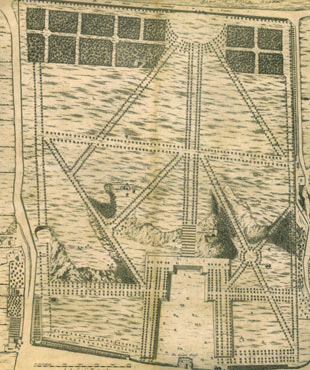
In May 1662, André Le Nôtre (who was designing the gardens for Louis XIV at Versailles), was asked to contribute to the designs. The only record of his input however is an annotated plan for a Parterre on the more level ground between the Queen’s House and the bottom of the Giant Steps (now often referred to as the Queen's field). Whether this was a new feature or a modification of a parterre designed by the Mollets is not known.
The Jonas Moore Manuscript map of the Thames from Westminster to its source commissioned in 1662
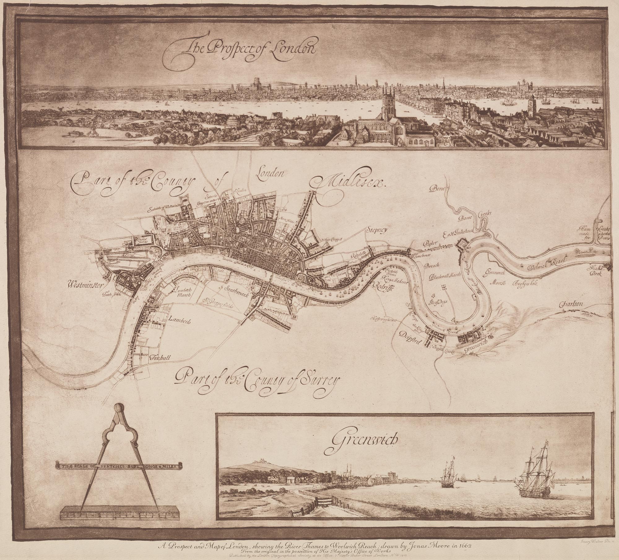
The section of Moore's 1662 Map published by the London Topographical Society in 1912. Reproduced courtesy of Yale University Library (see below)
"A MAPP OR description of the River of Thames from Westminster to the Sea with the falls of all the Rivers into it the severall Creekes Soundings & Depths thereof and Docks made for the use of his Maties Navy, made by Jonas Moore Gent: by Warrant from Sr Charles Harbord Knt, his said Maties Surveyor General. In Pursuance of his Maties Warrant and Command under his Royal Signature Anno Domini 1662"
The royal warrant to which Moore referred is dated 7 February 1662.
The plan (now preserved at The National Archives (Work38/331)) is large being more than six feet wide, two foot high and edged by a gold border with a black outline. Drawn on three pieces of joined velum, the map has become rather rubbed over time, possibly in part, because of people brushing past it when it was pinned to an office wall. As well as showing buildings, the map has a coat of arms (top centre), a cartouche containing the title above (bottom right) balanced by an image of a pair of dividers on a ruler (bottom left). There are also five good size watercolours? edged in gold. They are titled: The prospect of London (top left) and then in a row along the bottom from left to right: Greenwich, Wulwich (Woolwich), Erith and Graves End (Gravesend). They have been attributed by some to Wenceslaus Hollar, possibly on account of similarities between The prospect of London and known Hollar views. That said, no Hollar views remotely similar to the other four watercolours have been identified.
In 1662 St James's Park (which can be seen centre left) was in the middle of being landscaped for Charles II by the French Garden designers André and Gabriel Mollet who added the canal (in the centre of the Park) that runs from east to west. The map shows the works in progress and is the only map known that captures the Park before 'the rounds' were added at the eastern end of the canal. However, when it comes to the way in which Greenwich was depicted, the map is deficient. Not only is the landscaping of Greenwich Park not shown nor are any of the redevelopment works that were taking place in Greenwich Palace. What the plan does show is the the route of the road running through the middle of the Queen's House and Greenwich Castle which appears to be shown in tact, even though it was prossibly a ruin at that point.

Detail showing Greenwich Park, the Castle, the Tudor Palace and the Queen's House
As far as is known, the complete map has never been reproduced. However, the western third was reproduced in monochrome by the London Topographical Society in 1912 (below) and the western half in full colour as the endpapers in Philippa Glanville's London in Maps (1972). A cropped version of The London Topographical Society publication was included by Peter Whitfield in his book London in maps (2006/2017). Interestingly, the original seems to have suffered further damage since the 1912 copy was made.
Click here to read more about the state of Greenwich Casle in the 1660s and its date of demolition.
The 1912 copy of Moore's map is reproduced at reduced size from the digitized copy on the Yale University Library website (Call Number: 32 L84 1662/1912)
The plan of the parterre annotated by André Le Nôtre (André Le Nostre) in 1662-3?

� Biblioth�que de l�Institut de France (MS1605f.61)
Annotated in two hands, it is not clear who actually drew the plan which is orientated with the Queen's house (marked E) at the bottom. Researchers seem to agree that all the text apart from the darker text at the top and the bottom is in le Nôtre's hand. In his book Gardens of illusion: the genius of André Le Nostre, Franklin Hamilton Hazelhurst suggests that the darker text at the bottom (which translates as 'Plan of The House of Grenuche [for] the Queen of England') was written by Le Nôtre when he was in later life. Others disagree.
As proposed, the parterre was to have a seven arched grotto at the southern end on a raised terrace (top) in front of there was to be a large circular fountain, both being centred on the grand axis. Closer to the house, the plan shows two smaller octagonal fountains symmetrically located on either side. A key feature was the terrace walks on either side which were to sit at a higher level than the floor of the parterre. There is no evidence that Le Nôtre ever visited England and the siting of the grotto suggests either that he was unaware of the Giant Steps or that its integration with the steps was discussed in correspondence now lost. Howerer, a similar seven arch grotto designed by LeNôtre had recently been constructed at Vaux-le-Vicomte just outside Paris and it was probably his work there inspired the King to seek his help at Greenwich.
The document appears to be part of an ongoing correspondence between Le Nôtre and those laying out the parterre particularly with regard to the dimensions of the terraces. The darker text at the top (not in Le Nôtre's hand) translates as 'The slope of the great Terrace is 229 feet long as you will see it marked - which is the same length as your arches as they were marked. The return corner is 30 feet and from there to the trees 52 feet as marked'. Le Nôtre's input consists of additional drawings below the main plan which show the terraces with their dimensions marked together with six numbered notes, the last of which says if there are any problems, get in touch. It is not clear if the dimensions given are in English feet of French feet which were about 1.066 times larger.
In the event, the plan was abandoned, but not before the area had been leveled the, the terraces constructed and the avenues of trees planted on the eastern and western terraces. However, although the width of the level of the parterre at the southern end is marked on the plan as 229 feet, measurements of the parterre banks (as restored in the early 2020s) using google earth give a figure of about 200 English feet or 188 french feet. However, plans submitted prior to the restoration seem to suggest that at that time it was very close to 229 English feet. It is interesting to note that although there are several mentions of Le Nôtre in the planning application, no copy of the Le Nôtre plan was submitted in the Heritage Statement nor was there any analysis of it. Nor were any of the other early plans of the park reproduced. Indeed the Pepys plan – which is the earliest plan of the whole park – was not even mentioned.
Because of the way in which the Park evolved in the 1660s, the Le Nôtre plan cannot be considered in isolation (although this seems to have been largely the case in the past). We know that Le Nôtre's help was only sought for the first time in May 1662. But we also know for certain (see next section) that the giant steps, the 16 coppices at the south end of the Park and four walkes were in existence by June 1662. What we don't know for certain is if the four walkes all consisted of tree lined avenues. Nor do we know where in the Park they were located. Nor do we know what other avenues had already been planted or planned prior to Le Nôtre's involvement. Nor is it clear if Le Nôtre's help was sought for planning the Park in general or just for the parterre and perhaps the formal gardens to the north of the Queen's House. As a result, we don't know how many of the tree avenues shown in the Le Nôtre plan were designed by him and how many already existed.
The design for the Parterre is all about symmetry. But a closer look at the plan shows the two diagonal avenues going off at different angles to the central axis. This is important, because unlike the other avenues in the plan, they both continue up the scarp to the plateau that makes up the southern end of the Park.
High quality reproductions of the plan were published in colour by John Bold in his book Greenwich (2000) p.13 and in black & white by Hazelhurst. Of the two reproductions, that reproduced by Bold is the better as the resolution is great enough to read the annotations.
The Pepys Plan c.1677
The Pepys Plan, c.1677. � Royal Greenwich Heritage Trust
Only two copies of the Plan are known to survive. One is held by the Pepys Library in Cambridge from which the plan takes its name. The other was discovered by Derek Howse in the collections of the Greenwich Local History Library (which was later merged with the Borough Museum to form the Greenwich Heritage Centre which was later reconstituted as Royal Greenwich Heritage Trust). The Plan is untitled and is an unusual hybrid of plan view and bird's eye view, the viewpoint for the latter being an imaginary elevated position to the north of the Queen's House which is at the bottom. The Parterre is shown in perspective view and for this reason, the east and west Parterre banks do not run parallel to each other as might otherwise be expected.
Information about the early relandscaping of the Park is preserved in the financial accounts of Sir William Boreman in the following two locations at The National Archives:
- SP29/56 (Secretaries of State: State papers domestic, Charles II. Letters and Papers)
- E351/3428 (Exchequer: Pipe Office: Declared accounts. Works and Buildings (Miscellaneous).: Sir William Boreman. Works in Greenwich Park)
SP29/56/39&39.1 are single page documents. The first is a covering letter from Boreman that begins 'May it please yor Majesty'. The second is an unaudited breakdown of the money expended on the redevelopment of the Park between 1 September 1661 and 10 June 1662. The account is presented in three sections under the following headings:
- 14 Coppices
- 7 Walkes
- 12 Assents
E351/3428 contains Boreham's certified accounts for the period 1 September 1661 – 10 June 1662. Not only are these more detailed than those in SP29/56, but the money is accounted for differently. Spellings are different too. Of greater significance however is the fact that the stated number of Coppices and Walkes are also different. The numbers recorded in the document are:
- Coppices: 16
- Walkes: 4
- Ascents: number not specified
The number of coppices is also recorded as 16 being in a later set of Boreman's accounts covering the period 1662–1665 (SP29/116/14).
What this suggests is that the SP29/56 account was based on what had been planned and the E351 account on what was actually constructed. The coppices were at the southern end of the park and normal practice was to fell each coppice on a 14 year cycle, which would explain why 14 were originally planned. What is interesting is that the Pepy's Plan shows 13/14 coppices whilst the next three plans in this list all show 15/16.
This raises the intriguing possibility that the Pepys Plan was copied with some modifications from a now lost masterplan or artists impression that was drawn in 1663 or 1664 shortly after Le Nôtre became involved and that the masterplan itself was based on one of a couple of years before. This seems all the more likely as Sir Jonas Moore who commissioned the etchings from Thacker and Place was Surveyor General of the Ordnance and would almost certainly have access to any existing plans of the Park ... and why create an entirely new plan when an earlier plan could be easily adapted?
It would have been simple enough for Thacker or Place to copy the earlier plan, replace the Castle with the Observatory and scrub out the fountains from the Parterre. If this was the case, the failure to change the number of coppices from 14 to 16 requires explanation. Perhaps the exact number was considered unimportant. It is also possible, given their distance from the Observatory, that neither Thacker, Place nor Flamsteed realised that the number shown was no longer correct. Although it never happened, Flamsteed originally planned to publish all or most of the 12 Francis Place etchings in his Historia in the manner of earlier astronomers. As such, they were designed to show the Observatory in the best possible light. An earlier masterplan showing the avenues as complete would have suited Flamsteed's needs very well even if at the time of the Observatory's founding there were still many trees to be planted or re-planted.
The Thacker/Place topographical views are generally considered to be be accurate representation of what existed when they were drawn. Given that they the etching Facies Speculae Septen show just nine steps, it seems likely that just nine rather than twelve were originally constructed.
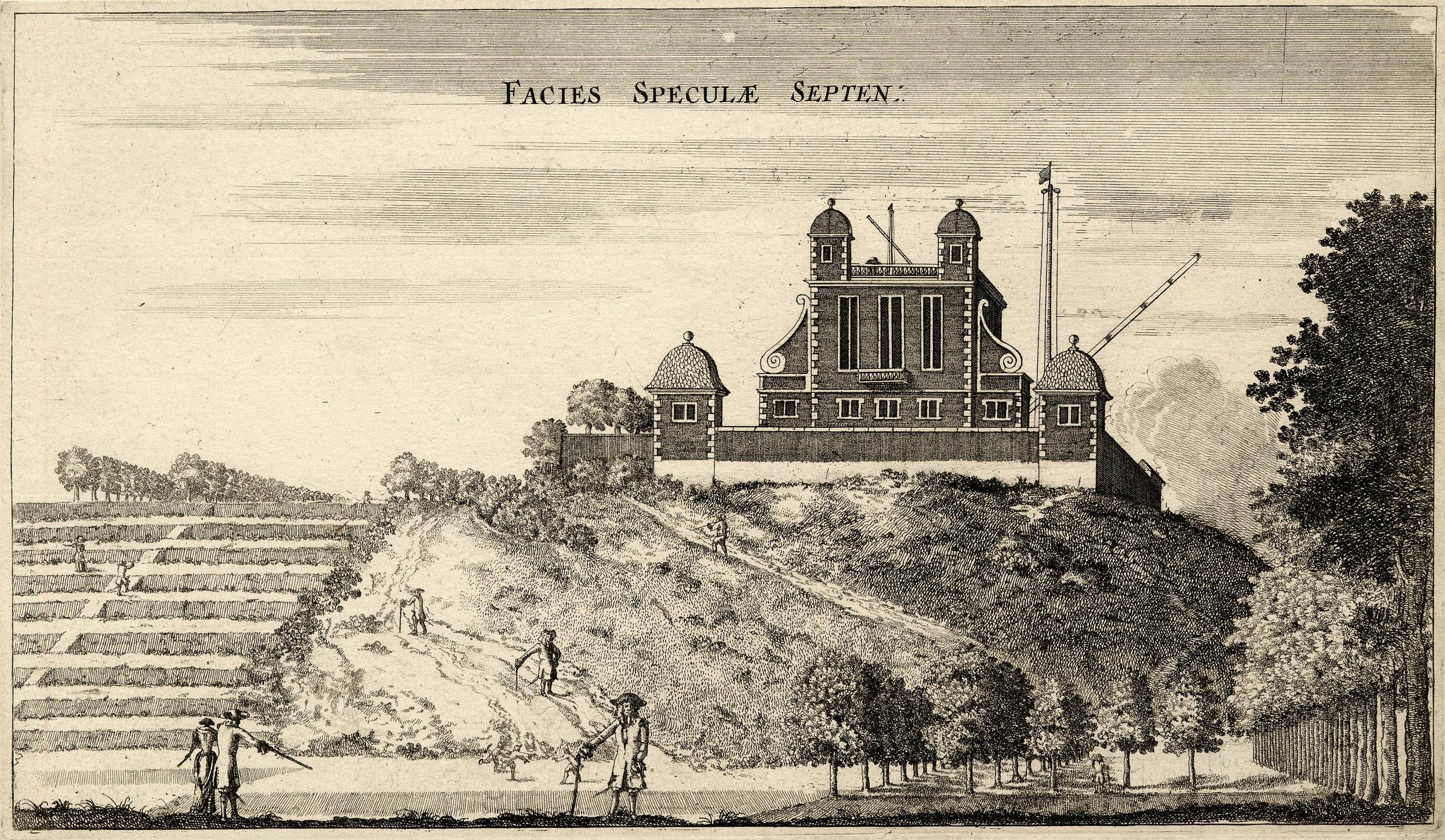
Facies Speculae Septen. � The Trustees of the British Museum (CC BY-NC-SA 4.0). Museum number: 1865,0610.949
There is no contemporary account in which the number of etchings completed by Place for Flamsteed is recorded. Given that there are only two known copies of the Pepys Plan, some have questioned whether it was really part of the set. The evidence that it is, is circumstantial but compelling. Firstly, when Pepys came to mount his collection of topographical prints in 1700, he mounted all the Francis Place etchings together (twelve in total), with the Title Plate being glued onto the rear of the Plan (which was folded in). More importantly, when writing to Abraham Sharp on 21 April 1721, Joseph Crosthwait (who was preparing Flamsteed's Historia for publication) wrote:
'There are about three sheets of the observations to print; which, as soon as finished, shall be sent you, with the pictures you desire. I should be glad to know whether you had ever the map of Greenwich Park, the plan of the Observatory, with the different prospects of it, sent: if you have not, I will send them, as soon as some few alterations are made in the plate of the Park.' (Baily p.343)
Although the alterations were not specified, it is known for a fact that the scale on the Pepys Plan is incorrect. It should have read ‘Scale of ‘Yards’, not ‘Scale of ‘Feet’. It is quite possible than it was also planned to change the number of steps on the Plan from twelve to nine and perhaps also to alter the number of copices.
The Gascoin Plan of 1693

The Gascoin Plan. � The National Archives

(photographed in two sections)
Drawn on parchment and coloured, this Plan is stored rolled and is grubby and much rubbed, particularly at the left and right edges. It is housed at the National Archives (MR1/329) and carries the title:
'An Actual SURVEyof the ground wereon their MASTIES antient Palace at GRENWICH (in the county of KENT) formerly stood wth the buildings theron newly erected and of the adjacent Park.'
A table in the bottom left hand corner contains about 40 entries and is headed: 'A Table of names for the respective parts of this Survey, wch was taken June 1693.'
The catalogue entry states the Plan was drawn by Joel Gascoin (Gascoyne?). Although his name does not appear to be present on the Plan itself, the form of the compass rose is similar to those on other plans he is known to have drawn. It also has a typically elaborate Cartouche.The Plan has misshapen features of which the most obvious is the lopsided Parterre immediately to the south of the Queen's House.
The stretch of land running outside the Park Wall from the current Macarney House to to the southern corner of the Park is marked as 'Mr Snapes house and garden'. The only buildings shown there are both on the site of Macartney House. The Rangers House is definitely not shown, nor does Park Corner House appear to be. A building may possibly be shown where Montague House was built, but further examination is required as it is not presently clear if the marking was made by Gascoin or if it is damage that has occurred as a result of rubbing.
The Travers Plan commisioned 7 November 1695, completed 1697

Detail showing Greenwich Park from the Travers survey. Lithographed at a reduced size by J & J Neele for inclusion in John Kimbell's An account of the legacies, gifts, rents, fees &c. appertaining to the church and poor of the parish of St Alphege Greenwich, in the County of Kent, ..., which was published in 1816.
'A SURVEY of the KINGS Lordship or Manor of EAST GREENWICH, in the County of KENT, within ye Bounds & Perambulation of ye Parish of GREENWICH; The PARK and DEMESN-LANDS there; With the Remains of His Maties PALACES and MANSION-HOUSES Situate either within or without the Limits of ye Ground lately Granted for Erecting an HOSPITAL for SEAMEN: As also the several CONDUIT-HEADS from whence the said Palaces and Mansion-Houses are or ought to be supplied wth Water, And the WAST-GROUND belonging to the said Manor, with the BUILDINGS and IMPROVEMTS. thereupon.
All which is truly described as ye same was found by ye View and Perambulation of the Commissioners and a Jury Impannelled and on Examination of Witnesses for that purpose by Virtue of His Maties Commission under ye Great Seal of England bearing date 7.o Nov. 1695. By SAMUEL TRAVERS Esqr. SURVEYOR GENERAL.'
When copying the Travers map, Kimbell/J&J Neale reduced the scale by a factor of two (making it roughly 60 cm square) and omitted much of the embellishment. Some of the labelling was also ommited, some of the wording modernised and the case of some lettering altered. In the copying process, at least one building not shown by Travers was added. Some of those omissions relevant to the digitised section shown here have been marked in pale green. They are:
- The labels for coduit Nos. 3, 4, &
- The label for the Ascent
- The label for the Terrace Walk(s).
- The 'house for fireworks' at the top of the Park
In common with the Gascoin Plan of 1693: the Parterre is lopsided and not properly centred on Blackheath Avenue. It would seem therefore that Travers copied this element from the earlier plan.
The stretch of Land running outside the western Park Wall from the current Macarney House to to the southern corner of the Park is recorded in the accompanying schedule as 'Three tenements and garden on the park wall, in the possession of Col. Stanley and others, now in lease to Nicholas Locke...' The buildings appear to be on the sites of Macartney House, the Rangers House and Park Corner House (now demolished). Montague House (also now demolished) is not shown.
The Woodlands Plan, post 1695

The Woodlands Plan. � Royal Greenwich Heritage Trust
LUC speculated that the gaps shown in the avenues of trees in the Woodlands Plan may have been the result of the Great Storm of 1703. Over the years, this has been restated by others as fact and become deeply embedded. What LUC actually said was (p.52):
'The 'Woodlands' plan, made sometime between 1703-20, confirms great losses of plateau trees [at the south end of the Park] compared to those shown in a 1695 plan [The Travers Plan]. This was probably due to the great storm of 1703, or may in part simply reflect the difficulties of establishing trees in the free draining plateau soils'
The speculation about the losses being due to the storm of 1703 is demonstrably incorrect as similar losses are shown on the 1693 Gascoin Plan. Although LUC were aware of the 1693 Gascoin plan on which the Travers Plan is partly based, they had clearly either never looked at it, not looked at it properly, or had a memory lapse. Likewise, it is also worth noting that the Travers Plan does not show the location of any trees.
The Wise Plan c.1714?

The Wise Plan (b/w) copy
' AN EXACT PLAN OF GREENWICH PARK describing all things thereunto belonging & adjacent: Viz the Queens house there, Keepers lodges, Avenues, Plantations, Hills, Vallys & other things remarkable therein; together with the Royall Hospital. Town of Greenwich, River of Thames'
The plan is missing the new road which had been constructed by 1695 but does show the whole of Greenwich Hospital which was not completed until 1751. The Hospital design however had been finalised by 1699. Haynes (2023) suggests the Plan was drawn by Charles Bridgeman for the gardener Henry Wise in about 1714 in conjunction with a plot of land he was about to sell to Greenwich Hospital for the building of an infirmary. The avenues are shown with no loss of trees suggesting either that the missing trees in the earlier plans had been replanted or that this was a very idealised view of the Park.
This is the first plan in which all four of the houses constructed adjacent to the western park wall at the southern end of the Park are shown (Macartney House, The Rangers House, Montague House and Park Corner House).
Copies of the plan are scarce. The National Maritime Museum however has one. Item reference: CMP/30
John Rocque's map, published 1746

An exact survey of the city's of London Westminster ye Borough of Southwark and the country near ten miles round begun in 1741 & ended in 1745 by John Rocque Land Surveyor & engrav'd by Richard Parr. Published 1746 (detail with recent hand colouring)
Rocque has named just two of the avenues in the Park. They are Love Walk (marked on the Gascoin and Travers Plans as Paul's Walk) and Brazen Face Walk (marked on the Gascoin and Travers Plans as Snow Hill Walk).
At the south end of the Park some of the boundaries between the coppices have disappeared. Although Montague House is shown adjacent to the southern part of the western park wall, Park corner House which is said to have been demolished in 1815 has been omitted.
The London Magazine plan published in March 1749
The Morris plan of the Parish of St Alphage from about 1834

Detail from A plan of the Parish of St. Alphage Greenwich in the county of Kent from an actual survey by W.R. Morris (detail). The plan is orientated with north west at the top and south east at the bottom. Reproduced by permission of the Greenwich Heritage Centre (see below)
The sayer Plan of 1840
The Sayer Plan updated to 1848
The Sayer Plan updated to 1850
Notes:
1. Park Corner House, date of construction.
NMM, 1729 (source) & (Source)
Julius Bryant (built by 1701)
Travers plan, 1695/7
Image
Sale: (source)
'Evening Post' No. 192, 1–4 March, 1728–29, advertises: 'To be Sold at Auction At Daniel's Coffee-house in Lombard-street on Tuesday March 11, 1728–29—A Messuage or Tenement, called PARK-CORNER House, situate upon the Corner of Greenwich Park Wall on Blackheath ... Printed particulars ... are deliver'd Gratis at ... Temple Exchange Coffee-house in Fleet-street. ...'
© 2014 – 2025 Graham Dolan
Except where indicated, all text and images are the copyright of Graham Dolan