…where east meets west
- Home
- Brief History
- The Greenwich Meridian
- Greenwich
(1675–1958) - Herstmonceux
(1948–1990) - Cambridge
(1990–1998) - Outstations (1822–1971)…
- – Chingford (1822–1924)
- – Deal
(1864–1927) - – Abinger
(1923–1957) - – Bristol & Bradford on Avon
(1939–1948) - – Bath
(1939–1949) - – Hartland
(1955–1967) - – Cape of Good Hope
(1959–1971)
- Administration…
- – Funding
- – Governance
- – Inventories
- – Pay
- – Regulations
- – Royal Warrants
- Contemporary Accounts
- People
- Publications
- Science
- Technology
- Telescopes
- Chronometers
- Clocks & Time
- Board of Longitude
- Libraries & Archives
- Visit
- Search
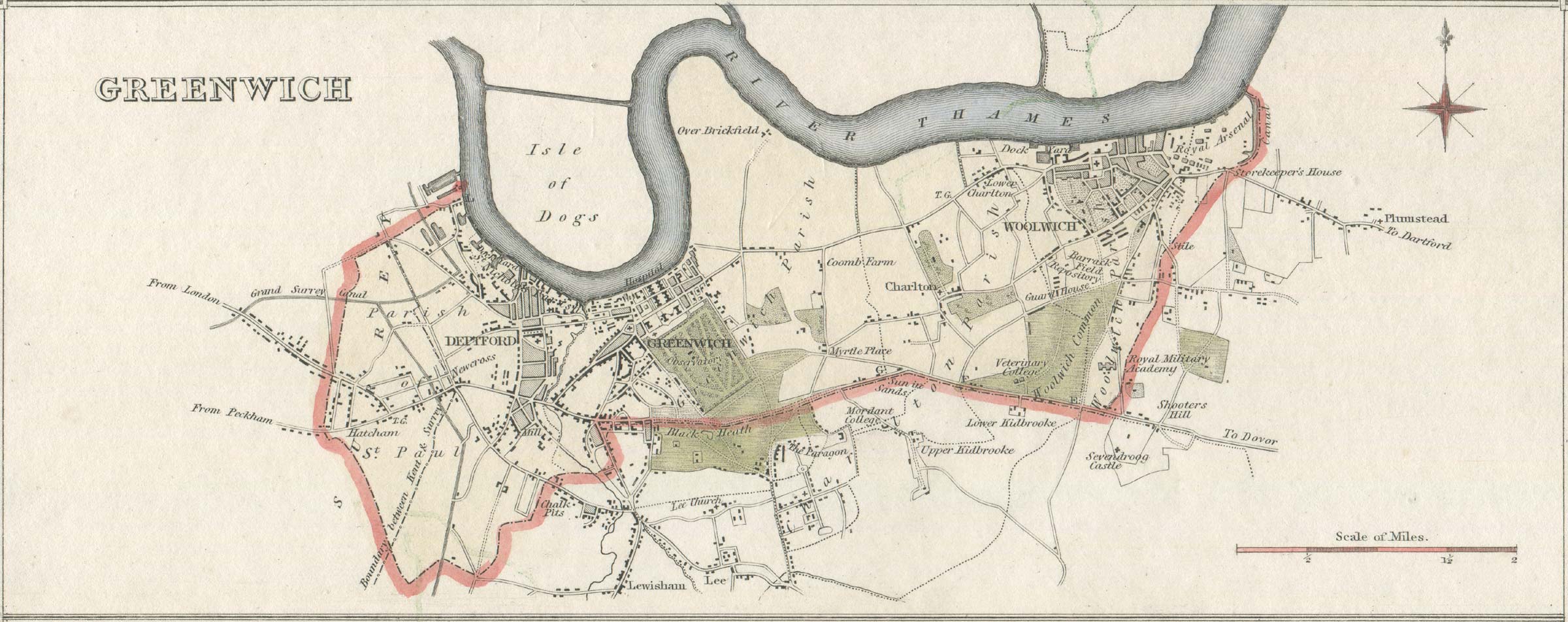
Historic maps of Greenwich
The maps and links on this page show the changing developments and street patterns in the neighbourhood of the Observatory.
See also: A guide to where members of the Observatory staff lived between 1822 and 1910
1695–97 (Samuel Travers)
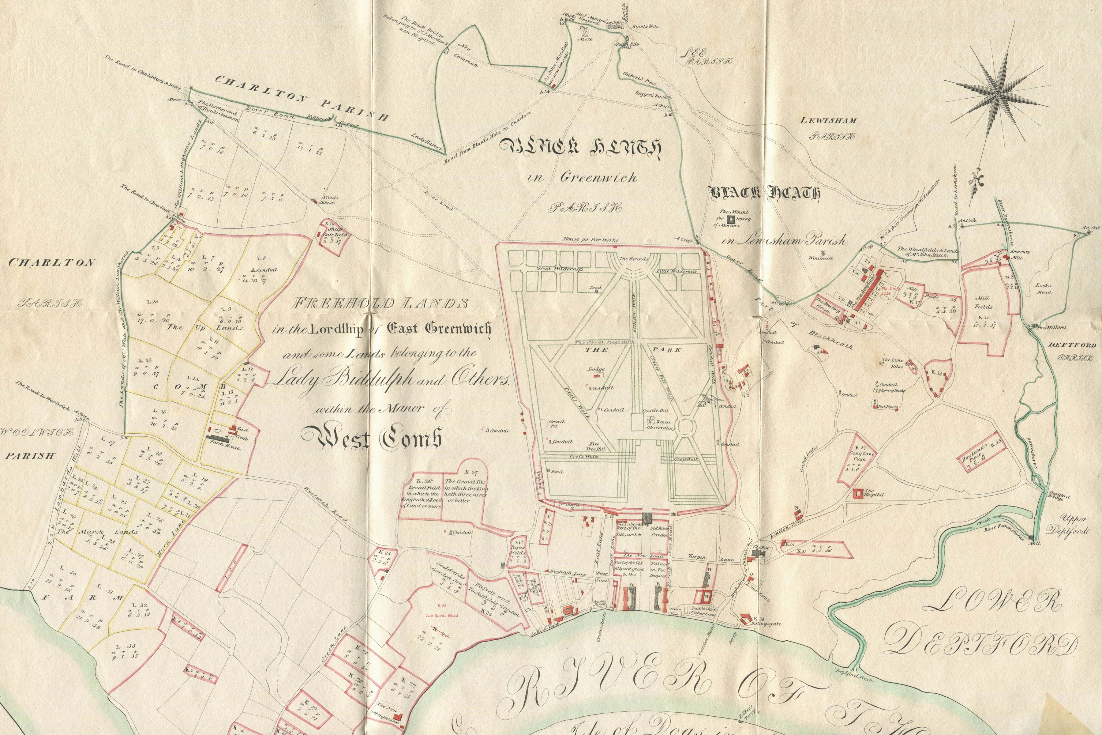
A survey of the Kings Lordship or Manor of East Greenwich in the County of Kent (top two thirds only): early nineteenth century copy with contemporary hand colouring. The survey was begun under the Surveyor General, Samuel Travers, on 24 February 1695 and completed on 27 May 1697. This copy was lithographed at a reduced size by J & J Neele for inclusion in John Kimbell's An account of the legacies, gifts, rents, fees &c. appertaining to the church and poor of the parish of St Alphege Greenwich, in the County of Kent, ..., which was published in 1816. The map has been drawn with north at the bottom and has been scanned in six sections which have been stitched together (with some ghosting at the joins)
The original map by Travers (from which the above copy was made) is drawn on parchment, coloured and measures 129.5 cm x 134 cm. It is preserved at the National Archives (MR1/253) and has an accompanying schedule (MPE1/245).
Click here to read a transcript of the schedule. Click here to skip straight to the key.
It is important to note that the purpose of the Survey was to identify the King’s property and the encroachments thereupon. As such, many of the other buildings that existed at the time have been omitted. Many of these can be seen in the view below.
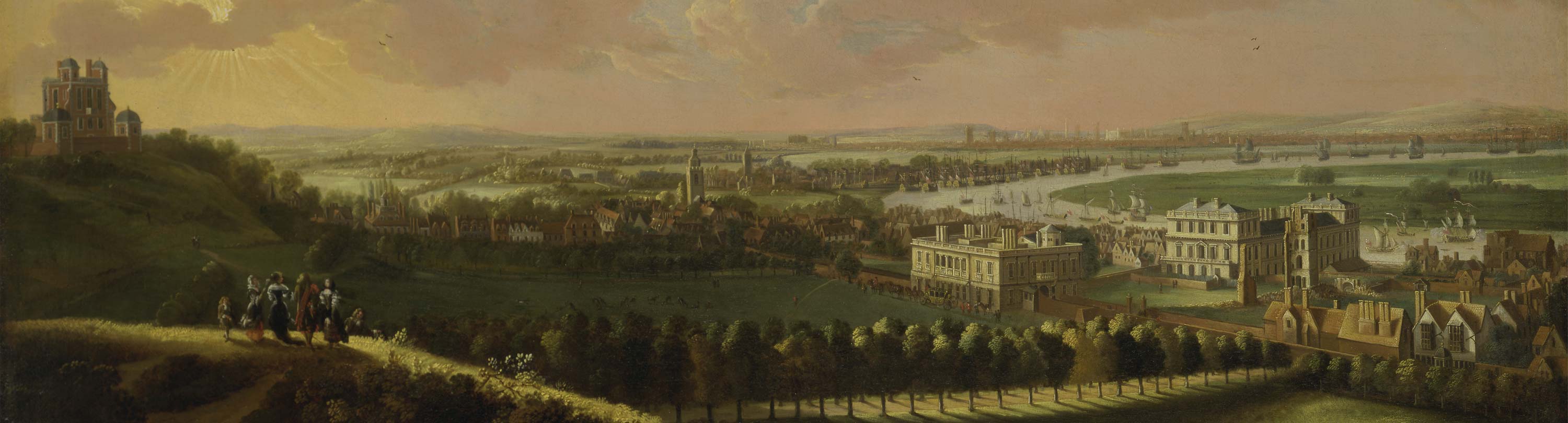
Dating from about 1680, this central section of a painting (attributed to Jan Vorsterman) shows London as seen from Greenwich Park. The Royal Observatory is standing on top of the hill to the left. Centre right is the Queen's House with the walled roadway from Woolwich to London running though it. To its right, the old Tudor Place is being redeveloped. Although much of the original Place was cleared in the 1660s and 1670s, Henry VIII's tiltyard towers are still standing (but are in the course of demolition). The west end of the former Palace chapel (demolished in the 1690s) is also visible on the extreme right next to the River. To its left, the large white building (by the River) is the unfinished wing of the first part of the New Palace. Incomplete and abandoned in 1672, it later formed the eastern range of the new King Charles court of Greenwich Hospital (now the Old Royal Naval College). In the centre of the picture, is the tower of St Alfege Church (rebuilt after the roof collapsed in 1710), with the tower of St Nicholas, Deptford and the Royal Dockyard to its right. The vicar of St Alphage’s from 1658 until he died in 1704 was Thomas Plume. He was well known to Flamsteed and in 1704 endowed the chair of the Plumian Professor of Astronomy and Experimental Philosophy at Cambridge. To the left of the church there is a row of houses running up the hill alongside the Park towards the Observatory. The large house on the left with a roof turret belonged to the Cottle family and is said to have been demolished (in 1813?) to allow George Street (now King George Street) to be created. Unsigned painting attributed to Jan Vorsterman (Yale Center for British Art)
When copying the Travers map, Kimbell reduced the scale by a factor of two (making it roughly 60 cm square) and omitted much of the embellishment. Whilst the original had a compass rose top left and bottom right, Kimbell drew just one which he placed top right in place of the Royal coat of arms. He also omitted some of the labelling, modernised some of the wording, changed the case of some lettering and inserted at least one building not shown by Travers.
Travers included the following text within a large cartouche that he positioned over the Isle of Dogs at the bottom of the map:
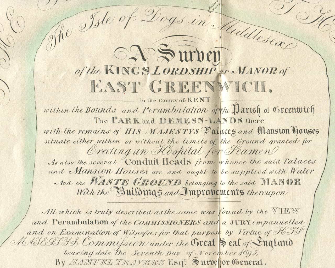
The contents of the cartouche as portrayed by Kimbell (scanned in two sections and stitched, with some minor ghosting at the join). Potter's Ferry (top) is Kimbell's addition and not marked on the Travers map
A SURVEY of the KINGS Lordship or Manor of EAST GREENWICH, in the County of KENT, within ye Bounds & Perambulation of ye Parish of GREENWICH, The PARK and DEMESN-LANDS there; With the Remains of His Maties PALACES and MANSION-HOUSES Situate either within or without the Limits of ye Ground lately Granted for Erecting an HOSPITAL for SEAMEN: As also the several CONDUIT-HEADS from whence the said Palaces and Mansion-Houses are or ought to be supplied wth Water, And the WAST-GROUND belonging to the said Manor, with the BUILDINGS and IMPROVEMTS. thereupon.
All which is truly described as ye same was found by ye View and Perambulation of the Commissioners and a Jury Impannelled and on Examination of Witnesses for that purpose by Virtue of His Maties Commission under ye Great Seal of England bearing date 7.o Nov. 1695. By SAMUEL TRAVERS Esqr. SURVEYOR GENERAL.
Kimbell’s copies of Travers’ map are relatively rare and eight have been investigated (to date). They appear to originate from two different lithographic plates. These contain the same errors and omissions, suggesting that either they were both produced from the same drawing (presumably copied by or for Kimbell from the parchment original), or, one was copied from the other. The two lithographic plates both carry the same annotation, but the exact placing and style of the text is different.
The version shown here (designated plate A) carries, in the bottom right-hand corner, the inscription J & J Neele, Lithog: 352 Strand – no date being given. Four similar copies are held by Greenwich Heritage Centre (one bound and three unbound). The J & J Neele, Lithog: 352 Strand inscription is absent on the otherwise identical copy bound into the copy of Kimbell’s book held in the Library of the National Maritime Museum (catalogue link).
Maps produced from the other plate (designated plate B) carry the inscription Reduced from the Original & Engraved by Geo. Neele; 11 Judd Place West, St. Pancras followed by a date. One variant carries the date 1815. The other (copy at Royal Museums Greenwich) carries the date 1812 and the additional inscription: J Kimbell scripsit (bottom centre). The 1815 version lacks the hand colouring, and both have been printed on paper that has considerably browned with age.
In copying the map, Kimbell made a number of errors and omissions. Some are identified below and except where indicated, these have been corrected on this digitised copy.
- Kimbell realigned the two avenues on the northern boundary.
- The Travers map shows 9 conduits (or sets of conduits). Kimbell was careless in replicating their precise locations (not corrected) and failed to label Nos. 3, 4, 5, 6 and 9. He also misrecorded No.1 as No.2.
- He failed to label The Dung hole behind T5 and T6 to the right of the Park and the Ascent (the Giant Steps outside the Observatory.
- He omitted The house for Fireworks at the top of the Park.
- The field on the river between Ballast Quay and the New magazine should have been marked K23 The Great Mead. Kimbell marked it as K25 and omitted its name.
- Potter’s Ferry (Isle of Dogs) is Kimbell’s addition and is not marked on the Travers map (not corrected). It appears on plate A, and plate B (1812), but not on plate B (1815).
Castle Hill (centre) later became known as Flamsteed Hill, whilst Gang lane (to the west (right) of Greenwich Park) is now known as Royal Hill. The new magazine (bottom centre-left by the River) was used for the storage of gunpowder and located well away from other buildings. An Act of Parliament for its relocation to Purfleeet was passed in 1759.
Note the presence of the Pest House which was erected in 1635 beyond the Park boundary to the right of the Observatory. This was where individuals with communicable and deadly diseases such as the plague or smallpox were isolated from the rest of the community. It was situated at a convenient distance from the centre of Greenwich and alone. It was replaced on the same site by the workhouse (which can be seen on the 1834 map below between Blissett Street and Maidenstone Hill). Following the relocation of the workhouse in 1840, a new road was created. This was called Cottage Place and later known as Dutton Street. It can be seen on the 1863 map (below). In the early 1850s two of the Observatory’s seven assistants (Thomas Ellis and Edwin Dunkin) together with one of the temporary computers (the brother of yet another assistant) all had houses within a few yards of each other in Cottage Place.
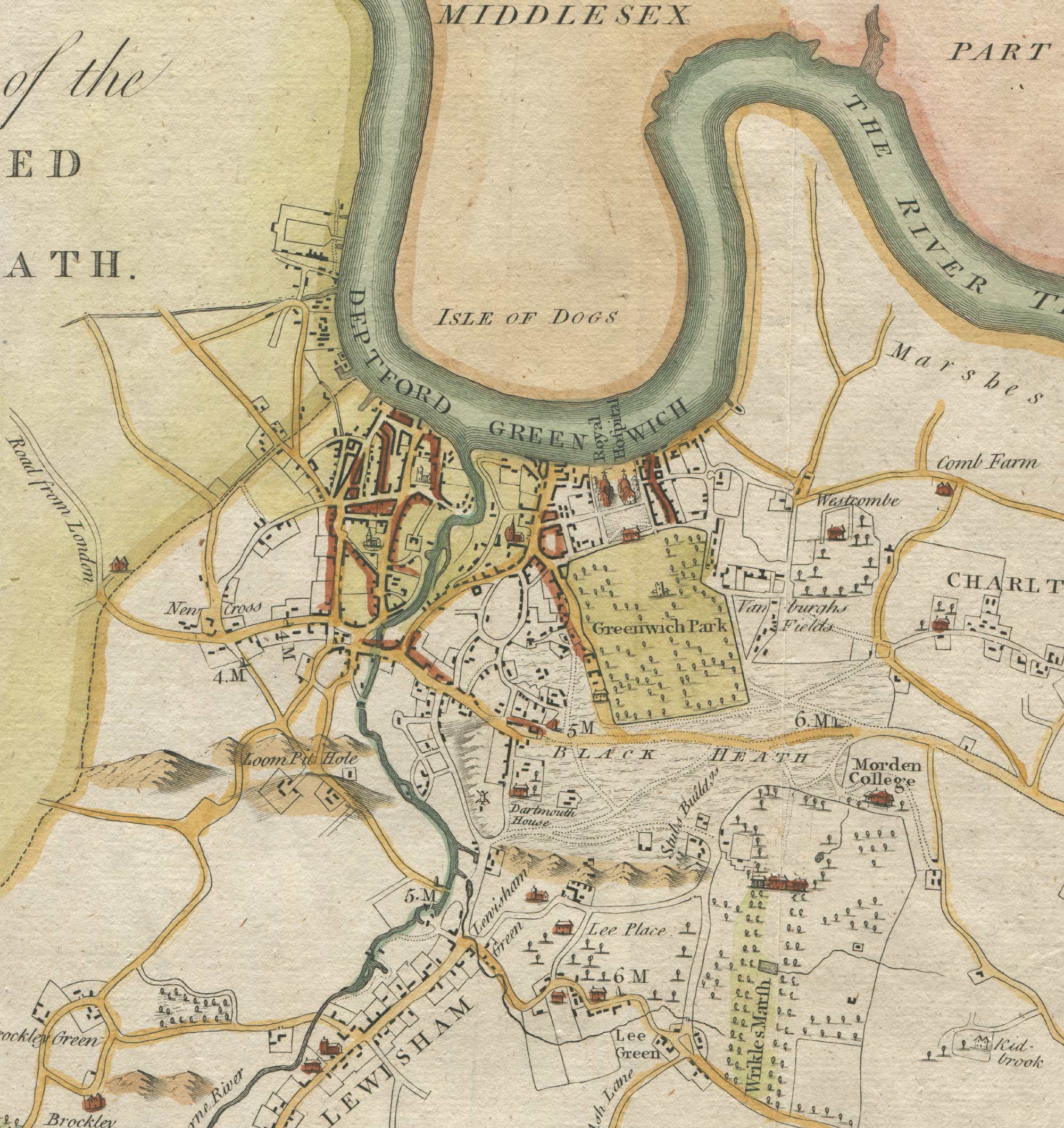
1746 (John Rocque)
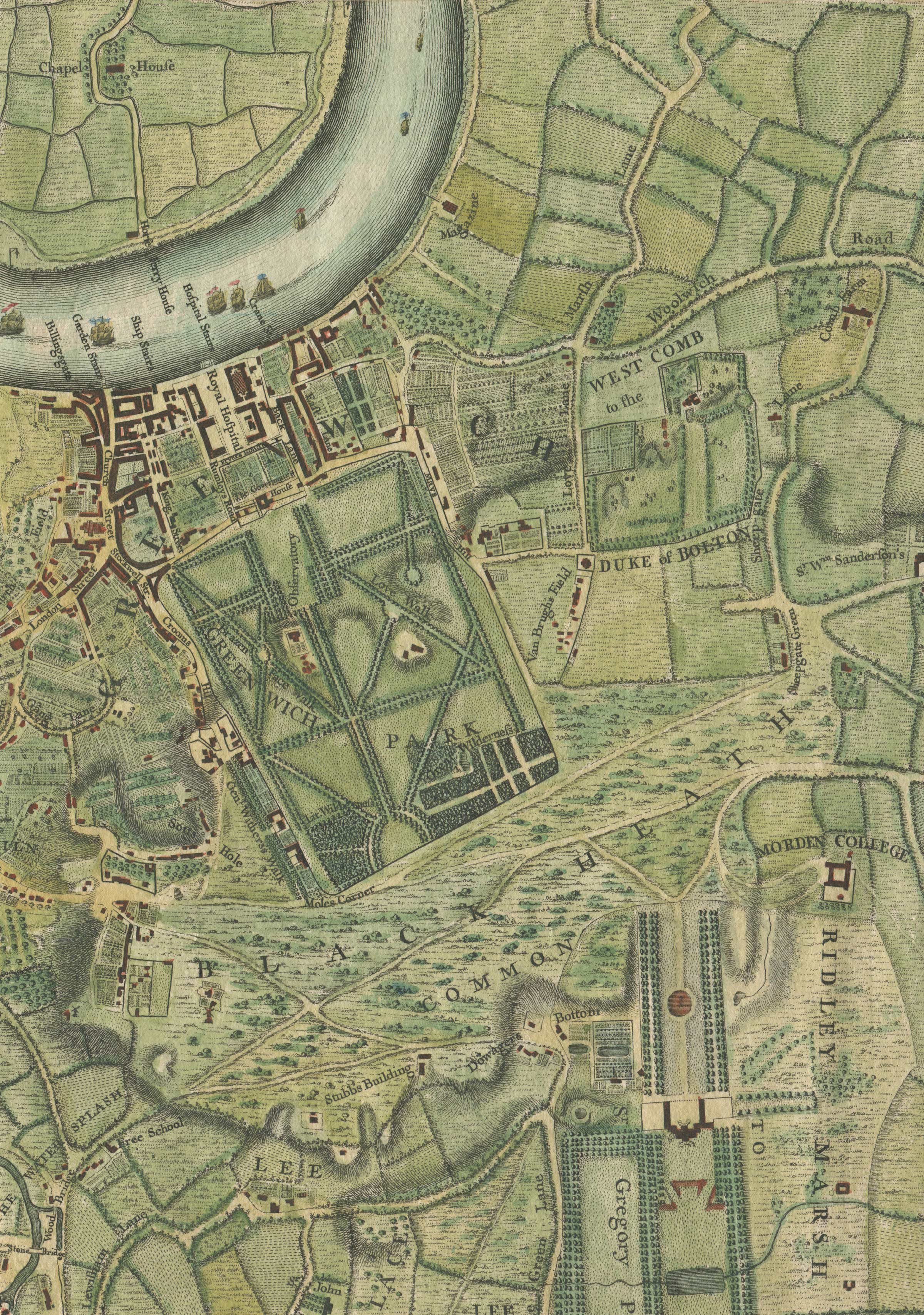
An exact survey of the city's of London Westminster ye Borough of Southwark and the country near ten miles round begun in 1741 & ended in 1745 / by John Rocque Land Surveyor & engrav'd by Richard Parr. Published 1746 (detail with recent hand colouring). Scanned in two sections and stitched, with some minor ghosting at the join
Prominent in the bottom right hand corner are Morden College and Wricklemarsh, the seat of Sir Gregory Page. Page bought the freehold of Wricklemarsh in 1723 from the executors of the widow of Sir John Morden, who had founded Morden College in 1695. Construction of a new house began soon afterwards. Designed by John James, who had succeeded Nicholas Hawksmoor as clerk of works at Greenwich Hospital, the house was completed within a year. It was described in a contemporary account as one of the finest mansions in England, resembling ‘a royal palace rather than a residence of a gentleman’. The house however was short-lived. When Page died in 1775 the house and its collections were left to his great-nephew who let it to a succession of tenants. He sold it in 1783 to John Cator, who struggled to find tenants and decided instead to demolish it, the materials being sold in a series of sales that began on 28 May 1787. By the turn of the century, most of the house had been demolished.

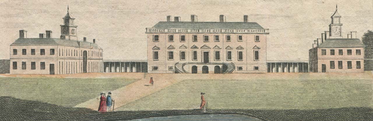
A contemporary view of Flamsteed House (centre of Greenwich Park) and the Ranger's House (north side of the Park and labelled by Rocque as The Governour's House, but now known as the Queens' House). From Volume 18 of The London Magazine (March 1749)
View of the seat of the late Sir Gregory Page on Blackheath in Kent (detail). Engraved by Page and published by Alexander Hogg c.1780
1778 (Edward Hasted)
A map of the Hundred of Blackheath (detail), published in 1778 by Edward Hasted as part of his History and Topographical Survey of the County of Kent
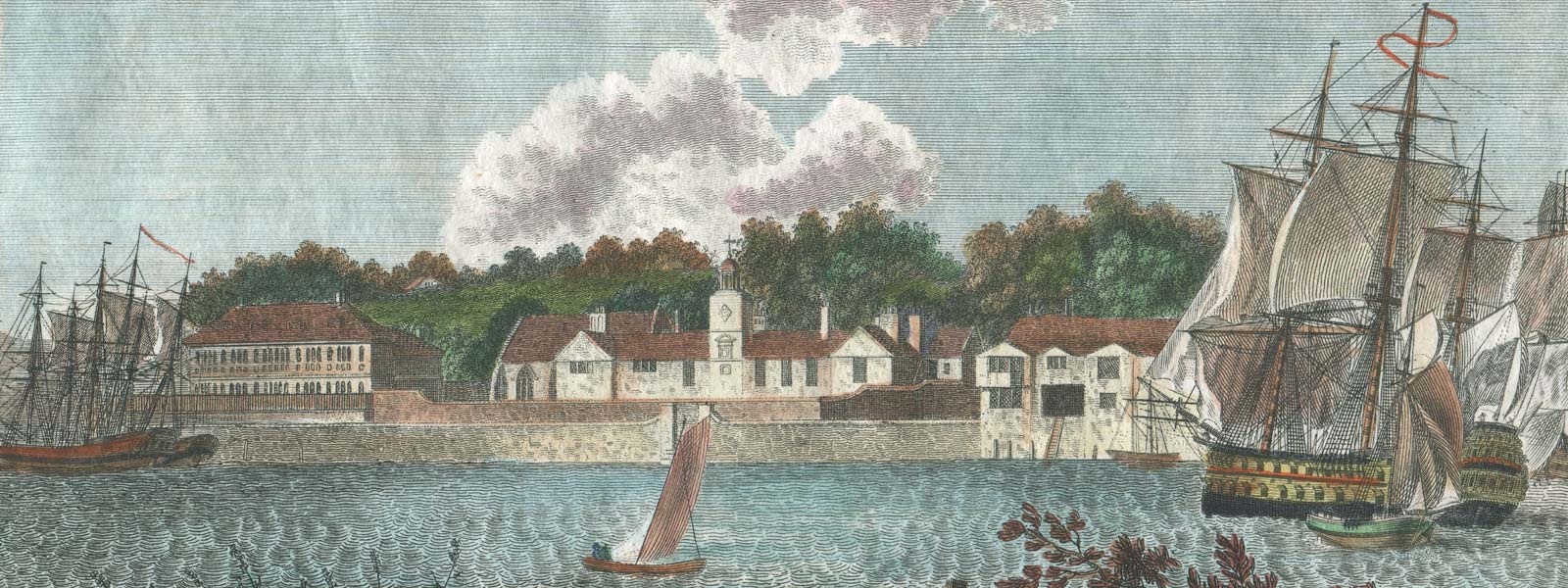
Dating from 1613 Trinity Hospital (centre), which was originally known as Norfolk College, is one of the oldest buildings in Greenwich. Crowley House to its left was begun in 1647 and demolished in 1855. Later used for a tramway depot, the site is now occupied by Greenwich Power Station. Detail from a 1796 engraving (with 21st century hand colouring) by James Peller Malcolm
1834 (Morris)
A plan of the Parish of St. Alphage Greenwich in the county of Kent from an actual survey by W.R. Morris (detail). The plan is undated and orientated with north west at the top and south east at the bottom. Reproduced by permission of the Greenwich Heritage Centre (see below)
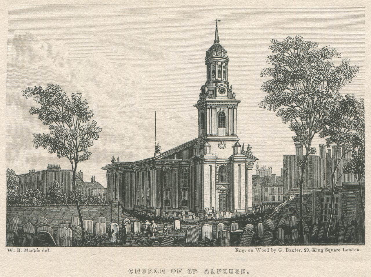
The parish church of St Alphage with the Observatory in the distance to it right. Engraved by George Baxter from a drawing by WB Mackie. From Henry Richardson's Greenwich: its history antiquities ... (1834)
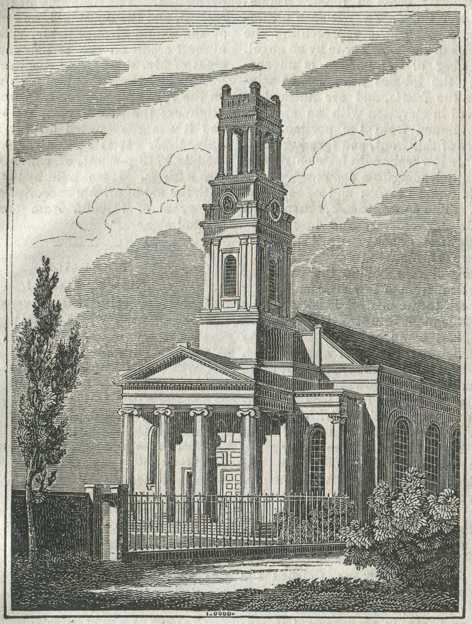
St Mary's Church, Greenwich (engraved by I. Dodd). Designed by George Basevi, the church was consecrated on 25 July 1825 and demolished in 1936. From the 18 September 1830 edition of The Mirror of Literature, Amusement, and Instruction
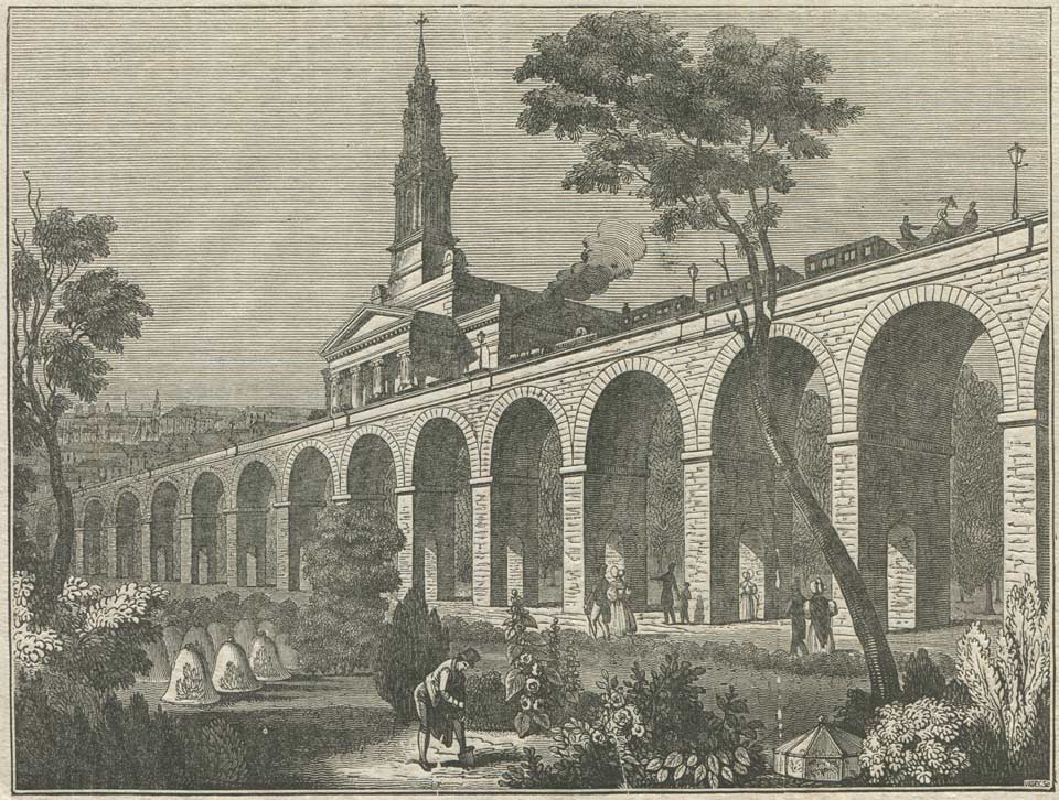
The London and Greenwich Railway, near Bermondsey New Church (Vasey Sc.). The line partially opened on 8 February 1836 (Spa Road to Deptford), and was fully open by 24 December 1838. Originally, the station at Greenwich was only temporary. The present building opened on 12 April 1840. From the 9 January 1836 edition of The Penny Magazine
The London and Greenwich Railway was under construction, but the building works had not yet reached Greenwich (the line opened in 1836).
The new roads to the west of the Park were only partially developed and several have since had their names slightly altered. The east side of the Park remained largely undeveloped.
Unlike the later Ordnance Survey maps, the names given to individual terraces of houses have also been marked.
Writing in 1834, local publisher Henry Richardson, described the recent changes that had occurred up to that point in time:
‘The Town is well paved; lighted with gas (for which an Act of Parliament was obtained in 1823); and supplied with water by the Kent Water-works at Deptford. Numerous improvements have been made in the Town during the last few years, which have greatly altered its appearance: to show the rural character of the place to a very recent period, it may be mentioned that within the last twenty years there were posts and rails to divide the footpath from the road on Croom’s Hill, and that till the year 1813 there were trees standing in the very centre of the Town, nearly opposite the Church. London Street, the leading thoroughfare on entering the Town from the Metropolis, has also, within the last thirty years, assumed a much altered appearance in its change of character from a street of private residences to one of commerce, almost every house within it now presenting a shop frontage; whereas, at the period alluded to, the shops were very few in number, and almost wholly confined to that end of the street nearest the centre of the Town.
Among the most prominent improvements may he noticed the following. The erection of the Creek Bridge and Bridge Street, the passage over the Ravensbourne at that place having previously been by a ferry, the approach to which was through Lamb Lane. The erection of Vansittart Terrace and Bexley Place. The re-building of Queen Elizabeth’s College. The widening of Maize Hill. The erection of Park Street, Park Terrace, and Maize Hill Chapel on a piece of ground on which stood a mansion formerly in the occupation of Sir Gregory Page, Sir Walter James, and more recently of Dr. Crombie, and which was pulled down in 1822. The new cut called Hyde Vale, leading from Royal Hill to Conduit Vale. The alteration at the foot of Blackheath Hill where the roads to Blackheath, Lewisham, Deptford, and Greenwich meet, the previous abrupt turning of the road having occasioned numerous accidents. The improvement of Limekiln Lane now called South Street. The formation of Nelson Street, leading direct from Church Street to the Royal Hospital and Woolwich; and the continuation of this improvement in the formation of Trafalgar Road, by which the former circuitous route to Woolwich is avoided. The lower Woolwich Road has also been materially improved since it was made a turnpike road, as previous to that the trees on each side of the road nearly met, and in some places the footpath was considerably above the road.’
Click here to read the rest of Richardson’s book.
1835 (Creighton)
Drawn by R. Creighton; engraved by J. & C. Walker. From: A Topographical Dictionary of England by Samuel Lewis. Published by S. Lewis and Co., London: 3rd Edition (1835). The map shows the electoral boundary (red) following the 1832 electoral reform act
This map shows considerably less detail than the 1834 plan above. The road layout to the west of the Park appears to be somwhat schematic and has only a passing resemblance to reality. This is probably because of the small scale used and the fact that the whole map as printed only measures 9 inches across.
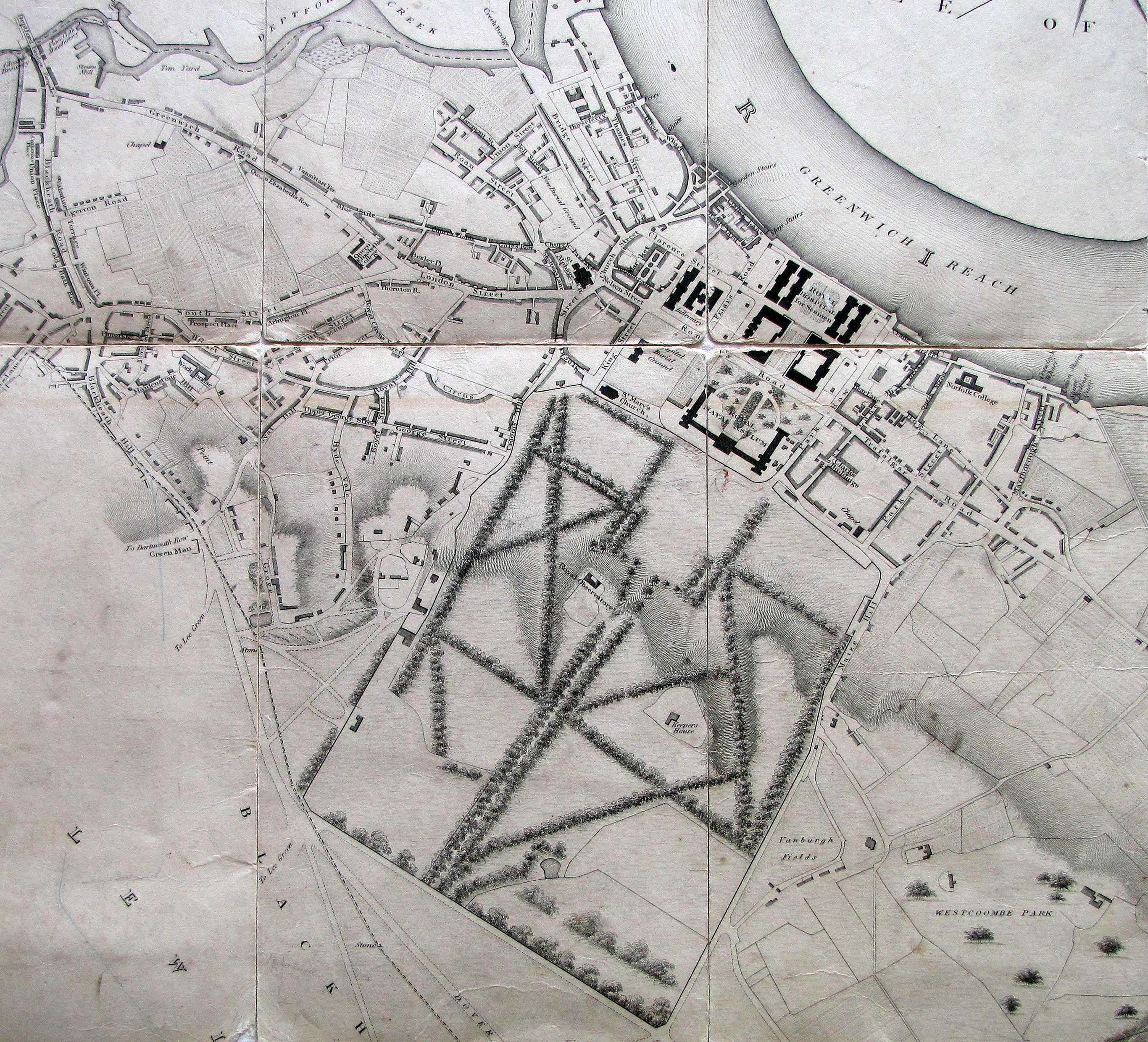
1861 (Weller)

Suburbs of London Sheet 2. Greenwich &c. Drawn and Engraved by Edward Weller and published by the Weekly Dispatch on 13 October 1861. The map has been scanned in four sections which have been stitched together (with some minor ghosting at the joins)
Since the Morris Survey of 1834 (above), the roads to the west of Greenwich Park have been fully developed as has the previously undeveloped area on the banks of the Thames to the east of Greenwich Hospital (top right). The area to the east of the Park remained largely undeveloped until the start of the 1880s when new roads were laid out and the area slowly built over.
As in the Morris survey, the names of individual terraces are marked on the Weller map. Many roads had developed in a piecemeal way and different sections were named and numbered accordingly. Hyde Vale for example, had Hyde Cottages and Glen Mohr Terrace on its eastern side, each independently numbered, and with the numbering running in opposite directions. In roads where the numbering was more rational, the numbers ran consecutively down one side of the road before crossing over and returning down the other. It wasn’t until the late 1800s that streets began to be numbered in the way with which we are now familiar with odd numbers being assigned to one side and even numbers to the other. With pre-existing roads, if the road had been built as a piece and numbered consecutively the old numbering pattern was sometimes retained; otherwise, the entire street was renumbered.
Ordnance Survey Maps
The National Library of Scotland has digitised its collection of historic Ordnance Survey maps and made them available online. The links below are to some of those published at the scale of six inches to one statute mile. Maps on the larger scale of 25 inches to one statute mile are also available. At this scale however, several sheets need to be viewed together to see all of the area within a mile or so of the Observatory. Click here to access the 25 inch maps.
1862–73
Ordnance survey map: surveyed 1862–73, published 1870–1872.
1893–94
Ordnance survey map: revised and resurveyed 1893–94. Edition of 1894–1896.
1908–14
Ordnance survey map: revised 1907–8,1914 and later. Edition of 1920.
Acknowledgements
Special thanks are due to the Greenwich Heritage Centre for permission to reproduce the detail from the 1834 plan of the Parish of St. Alphage.
© 2014 – 2026 Graham Dolan
Except where indicated, all text and images are the copyright of Graham Dolan